
Waymarks in the Vosges
In the north-east corner of France, the round tree-covered hills of the Vosges are the territory of the Club Vosgien. Founded in 1872, 75 years before the CNSGR/FFRP, and recognised as utilité publique in 1879, the Club operates a unique and highly effective waymarking system.
The Club publishes a series of comprehensive footpath maps. These are basically the standard IGN maps overprinted with footpath information, and they come at scales of both 1:25,000 and a very useful 1:50,000. They show the region criss-crossed with a network of paths. Each section of path on the map is identified by a code consisting of a number (1 – 9) and a letter (a – e).
On the cover of the map is a table showing that each number corresponds to a shape, and each letter to a colour. Here is the table.
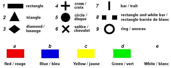
 So looking at the map, you decide you want to follow path 2c to its junction with path 3a, then follow the 3a. A quick check with the key tells you that the waymarks for your first path – 2c – are yellow triangles, and then when you find red diamonds you know you’ve found path 3a. Simple!
 GR paths are assigned the number 1 (rectangle), and as far as possible the colour red. Where there might be confusion, other colour rectangles are used. This waymarking is in addition to the standard FFRP waymarking for GRs and GRPs.
Like the FFRP’s waymarks, the Club’s waymarking system is registered and protected under French trademark laws.
The Club’s volunteers maintain a network of 16,500km of paths in the seven départements of Eastern France.
Update September 2019. It seems the Club Vosgien no longer publishes its own maps with the number/letter combinations marked. Instead, some symbols are shown on the IGN TOP25 maps which carry the Club’s logo but the one example I bought showed relatively few waymarked tracks. There were many more on the ground which weren’t on the map. See more in my trip report here.