The Segnas Pass
Flims – Elm, 6 September 2003
This post is part of the story of a three-day walk in south-east Switzerland. See this article for the main story.
The Segnas Hut (Camona da Segnas)
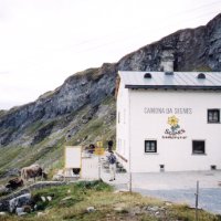
The Segneshütte
We started by getting the bus from Chur to Flims, and left Flims (1080m) at 0850. Yellow signposts pointed the way to the Segnas Hut (Camona da Segnas, or Segneshütte) via the route we’d picked out on the map. A good driveable track climbs steadily, with one or two steeper sections, via the ski-lift station of Foppa and Punt Desch (a bridge). Even with heavy packs we made good time – each hour was 400m climbed, then a 10 minute stop, giving an average of 340m per hour. We reached the hut (2100m) in 2h40′, against a signpost time of 3h15′. The weather was fine – clear, with some cloud, and mild temperatures. Quite a few people were at the hut: we stopped for coffee before setting off again at 1155.
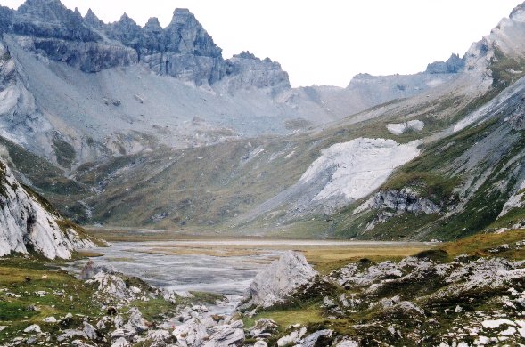
Flat
Beyond the hut the path drops slightly to an area that had intrigued us looking at the map. It’s shown as completely flat, with not a single contour line over an area of about 2km by half a kilometre. The path skirts the right hand edge of this dry bed of what must have been a glacial lake. Now only a few streams make their way in braids across the flat stony surface. This amphitheatre is surrounded by towering shattered ridges and pinnacles, light grey in colour, and scoured clean of vegetation. It can only have been some time last century since this whole area was under ice.
Martinsloch
Martinsloch
As you go higher, the amazing feature of the Martinsloch comes into view on the left. This is a hole right through the rock ridge of the Tschingelhoren, 17 meters high and 19 wide, bigger than any other I’ve seen. It’s marked on the map, and features as an attraction of Elm on the other side of the pass. Twice a year, near the spring and autumn equinoxes, the sun shines through the hole and sends a shaft of light which hits the church tower. In exceptional years the full moon also does the same. Googling “Martinsloch” will give you several pages about the phenomenon (in German).
Barren
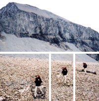
You can see the far end of the cirque all the way from the hut: we were heading for a lower section of the ridge between the shattered towers of the Tschingelhoren and the SW ridge of Piz Segnas. The caffeine high from our coffee at the hut lasted us across the dry lake bed and up the short steep section which follows. Then, as hunger took over, we stopped for lunch before the steady easy climb towards the head of the cirque. Nearing the end the ground is stony and barren, with red and white waymarks showing the route. This could be a problem in mist or under snow, although following a compass bearing would not lead you into any difficulties.
The Pass
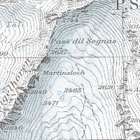
Segnas Pass map detail
The stony ground ends at the foot of a 100m headwall. The path at this point is shown as intermittent on the map, and we had been looking for signs on the ground, assuming it went up the lightly vegetated section at the right-hand end of the gap. It was only when we were quite close that we spotted red and white marks on the left, leading to a point on the ridge immediately at the foot of a vertical section at the end of the Tschingelhoren ridge. We could make out a signpost on the col.
At the Col
Light rain started. The path heads up zigzags over loose black scree to the foot of a final gully. There are fixed chains, and for the last section, stanchions in the rock. We scrambled and hauled ourselves up the last 30m, reaching the top at 1425. The rain was steadier now, and there were no views. The narrow ridge, with a sharp drop on the other side, marks the boundary between the cantons of Graubunden and Glarus. A closed and shuttered building to the right, out of sight from the ascent side, is a military building not open to passers-by. The path slithers across to this, then down scree, and soon reaches better ground. The rain eased off as we lost height, and finally stopped.
A long way down
We were now in new scenery – still with towering pinnacles and walls, but also views straight down into the valley with alpine meadows and trees. There’s much evidence of recent glaciation. The drop to Elm is more than the climb from Flims, and in much less distance. The path is varied, but unrelentingly steep and tiring. Martinsloch is in view most of the way. The last section follows a deep ravine, again glacier-scoured to a depth of many hundred meters, but the glacier has gone. We finally reached a tarmac road which took us to the main road in the valley just below the village, and reached the village itself at 1830. Going carefully with tired legs had taken more time than we’d expected.
| ascent | descent | time | distance |
|---|---|---|---|
| 1547m | 1657m | 5h10′ to pass 4h to Elm |
~17km |