
Around Glencoe
October 2003
Introduction
This week I was based on the north shore of Loch Leven, leading a “Munro Bagging” holiday for HF Holidays. The week was badly affected by gales: wind speeds on the summits and high ridges never fell below 40mph, and on several days reached 60 gusting to maybe 70mph. The hill forecast for Friday predicted winds further north in the Western Highlands gusting to 100mph.
Munros in bold, tops in normal text, * = climbed previously. All grid references have prefix NN, and are on OS 1:50,000 series sheet numbers 41 or 50.
Thanks to Clive T for all the display photos on this page!
Diary
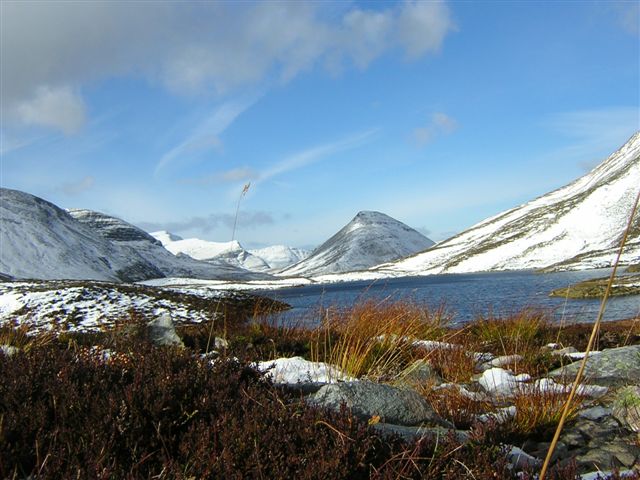
Sunday 5 October – Glencoe
Stob an Fhuarain – Sgor na h-Ulaidh
We followed the Gleann-leac-na-muidhe track to the gate just before the farm and headed up the hillside beside the plantation. There is 650 metres of climbing on rough grass (no path) at an angle of 35 – 40 degrees to reach the ridge. Once on the ridge there is an intermittent path over Stob an Fhuarain to the main summit. Fence posts indicate the path down the NW ridge and into the glen. Slippery slabs need a wide detour on the right to avoid difficulties in the wet. We crossed to the R side of the river and followed it back to the farm and our pick-up point. We were in mist and rain from the time we reached the ridge.
From start of Gleann-leac-na-muidhe track at 118565: 12km; 1180m
Monday 6 October – Glen Leven
Today’s forecast was for 60mph winds at 900m, gusting to 70mph, so the “Munro Bagging” group joined the “Classic Walking” mid-level group. We started at Callert on the Kinlochleven road (095603) and followed the right of way north to the first col. A few guests were prepared to tackle Mam na Gualainn (796m, a Corbett), so we headed up the broad ridge. At the top the wind was about 50mph, gusting to 60mph. We continued along the ridge over Beinn na Caillich, and then dropped down the well-graded zig-zag path which joins the West Highland Way on the old military road, which we followed into Kinlochleven for our pick-up.
Tuesday 7 October – Mamores
Overnight snow was lying down to about 400m, and gale-force winds were again forecast. My original plan for a day in the Mamores had been to climb Binnean Beag, Binnean Mor and Na Gruagaichean, but given the conditions I decided to try something shorter and just aim for Sgurr Eilde Mor.
Our bus took us to Mamore Lodge (185629) from where we followed the track towards Loch Eilde Mor, then taking the clear stalkers’ path at 208635 which heads NW then N to Coire an Lochan. Although the lowest-lying snow was clearing in the morning sun, by the time we reached the Coire in the lee of the overnight winds the path was completely covered, with drifts up to a foot deep. The surrounding snow-covered mountains looked splendid against the blue sky. Fifteen minutes later we were crouched in a small hollow sheltering from a 50mph hailstorm while we grabbed a quick lunch!
Coire an Lochan, later in the day
With fresh wet snow on the rocks and boulders of Sgurr Eilde Mor, a 260m climb fully exposed to the wind, and plumes of spindrift being driven off the summit it was an easy decision to abandon any further climbing. We crossed to the SE corner of the Lochan and headed down the slope near the outflow stream, soon picking up another well-made stalkers’ path which joins the lochside track at 222638 for a return to the Mamore Lodge Hotel bar.
Wednesday 8 October – Glencoe
My day off, and although it was a clear morning the gales were continuing. I opted for an easy day and set off to climb Sgorr na Ciche (the Pap of Glencoe), which I hadn’t climbed before. Thanks to David C for giving me a lift to the start. The path to the top is clear, and though steep in parts is well graded. I was lucky to be able to enjoy the all-round views from the top.
Back down, I walked through Glencoe village for coffee and carrot cake at Crafts & Things (at the end of the village on the A82), called in to buy some new gloves at Glencoe Gear and Guides next door, then as there wasn’t a bus for an hour and a half walked back to the house.
From the old Glencoe road at 111586: 745m; 3h15′ up and down.
Thursday 9 October – Grey Corries
Beinn na Socaich – Stob Coire Easain – Stob Coire an Laoigh – Caisteal – Stob Coire Cath na Sine – Stob a’ Choire Leith – Stob Choire Claurigh* – Stob Coire na Gaibhre*
Our redoubtable driver Rosemary of White Heather Travel in Fort William drove us up the track towards the forest from Corriechoille. A short negotiation with the keeper and stalkers who flagged us down saw us on our way on the understanding we were headed for the Grey Corries, but it was made clear we weren’t to take the bus any further up the track.
Just before the forest gate the old rail trackway which used to serve the aluminium works in Fort William crosses the track. We followed it two and a half kilometres SW to a stile into the forest, forced our way through to a forest track and headed S to the dam on the Allt Choimhlidh. A path over a stile by the dam leads a short distance up the E bank of the river to a crossing point. Some managed to cross dry-shod, others opted for wet feet. The crossing would be more difficult with the river in spate.
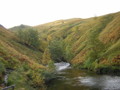
Above the Dam on the Allt Choimhlidh
We took a fairly direct diagonal line up the long grassy slope, reaching the ridge of Beinn na Socaich at a height of about 800m. From now on we were exposed to the gale-force winds, which were blowing from the NW or W. Intermittent mist and rain alternated with brighter periods and the occasional glimpse of blue sky, but the wind was always with us, blowing at around 50 – 55 mph and gusting to over 60mph, when staying upright is difficult.
Once we had reached Stob Coire Easain we turned E with the wind more or less behind us, and the chain of summits followed one after the other. The rain became more persistent but the wind moderated a little. It was a relief to start the descent to the last top, Stob Coire na Gaibhre, which from this direction is hardly more than a bump in the N ridge of Stob Choire Claurigh. We finally got out of the wind as we lost more height, but by this time we had been in the full force of the gale for 4 hours. Eventually we dropped down the last steep grass slope to join the forest track near the top gate and set a quick pace back to Rosemary waiting with the bus.
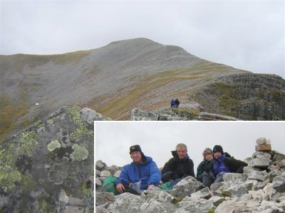
The Grey Corries
(inset) Tony, Martin, Jennifer, Peter
From Corriechoille forest track at 253794 : 18km; 1600m; 7h45′
Friday 10 October – Black Mount
Stob a’ Choire Odhair
Once again the forecast gales called for a change of plan and I decided to head for Glen Orchy in the hope that we could approach Stob a’ Choire Odhair from the sheltered side. Despite warnings from the King’s House hotel that vehicles were having difficulty crossing Rannoch Moor we made the journey without any trouble – though Rosemary said later that her return journey heading into the wind was “interesting”!
The climb from Forest Lodge via the Allt Toaig and a well-graded zig-zag stalkers’ path up the SSW ridge of Stob a’ Choire Odhair was uneventful. We came into the wind about 1km from the summit and about 200m below it, but it was much gentler than the day before – perhaps only 40mph. It was still too cool to linger on the summit, but we did stay for a few minutes looking at the view into Coire Ba and over to Rannoch Moor. We came down by the same path, and from Forest Lodge carried on down the road (here also the West Highland Way) for a kilometre to wait for the bus in the Walkers’ Bar of the friendly Inveroran Hotel.
From Forest Lodge (270423), returning to Inveroran Hotel (274414): 12km; 840m; 4h15′