
A Small Part of a Big Walk
The Big Walk
Across Switzerland
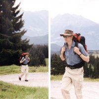
Jonathan en route
On 31 August 2003 our son Jonathan arrived in Val Müstair in the east of Switzerland, close to the Italian border. This was the start of a walk across Switzerland which took him via Zurich, Basel, and Bern to Geneva in the west. The whole trip lasted seven weeks and took him through four languages and 14 cantons, hiking over mountain passes and strolling through international cities.
The reason for the Walk was to gather material for a book about Switzerland. Here he explains why he wanted to write it.
I believe there is more to the country than dark brown chocolate and snow-white mountains. Many aspects of it fascinate me – not least its paradoxes. It is surrounded by major economic nations, yet stands aloof from the European Union and only joined the UN in 2002. Despite welcoming visitors from across the world, few of them seem to take away any sense of modern Switzerland. It has a peculiar political structure, a tainted 20th century history, and more official languages than any other western nation. It is neutral, peaceful and famously wealthy, yet still suffers from social ills and is so conservative that women in one canton had to wait until 1990 to get local voting rights. All this astonishes and intrigues me.
Each area I pass through lends itself to a particular aspect of “Swissness”, which I shall explore both through pre-arranged interviews and through chance conversations. My walk will form the backdrop to these encounters, themselves reinforced by extensive research.
[From an article that first appeared on www.uk-ch.org (no longer available)]
I joined Jonathan a few days into the Walk to keep him company through some mountainous country which could have been difficult for someone on their own, particularly if conditions had been bad. This is my account of those days, which took us from Davos to Amden*.
Davos – Chur, 4 Sept 2003
Panorama
We took the Parsennbahn mountain railway to the Hohenweg station at 2218m. A short steep path leads to the nearly level Panoramaweg which runs along the side of the SE ridge of the Schiahorn. There’s a significant stonefall risk here (warning signs). The path rounds the ridge and climbs gradually to the Strela Pass (2350m). There are views down to Davos most of the way, but the scenery is generally better once the ridge has been turned.
Strela Pass
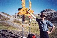
At the Strela Pass
We didn’t call at the Strela Pass restaurant, but we did stop to look at the view over to the far side of Rhine valley. The path drops steeply until it crosses a stream, then continues, becoming a driveable track, and dropping moderately steeply all the way to the tarmac road at Langwies, where we had lunch.
Impasse
The road to Chur is signposted as 22km. A succession of ravines cuts into both sides of the valley, which suffers from obvious landslips. The road winds in and out of each ravine. Our problem came with the first tunnel. The map shows a track by-passing the tunnel – this turns out to be the old road. Unfortunately, a landslide has taken out the crucial final section, so we’d hit an impasse. Walking through the tunnel would have been too dangerous, but we were lucky to be able to hitch a lift.
Train
We continued on the road through Peist to St Peter, where we stopped for drinks and to study the map for the other two tunnels. Now we knew what to look for, we realised we probably couldn’t get past either of them. Discretion overcame foolhardiness, and we decided to get the train to Chur from nearby Molinis.
| ascent | descent | time | distance |
|---|---|---|---|
| 265m | 1278m | 5h50′ | ~18km |
Chur – Elm: The Segnas Pass, 6 Sept 2003
There’s not much information in English about the Segnas Pass on the Web, so I’ve given it its own page on this link.
Elm – Murgsee, 7 Sept 2003
Lunch
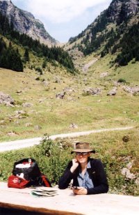
Lunch stop
Having stayed overnight at Elm, we walked down the valley on good tracks parallel to and alongside the river for about 8km to Engi. From there we took a signposted forest track, steep in places and criss-crossing the river, to the bridge at Ueblital (1190m). The weather was sunny and warm, and we ate lunch at a convenient picnic table.
Cows
From Ueblital we took the side valley north, which climbs via the Wildersteiner Hüttli to the Wildersteiner Furggel (= pass). This is a steady, moderately steep zig-zag path knee deep in cowpats. The Wildersteiner Hüttli is out of sight until you crest the skyline. It seems not to be a mountain restaurant. The gradient to the pass from the hut is easier. Murgsee is in view from the col, though neither of the two buildings you can see is the Murgsee hut – that’s hidden behind a small shoulder to the right.
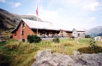
Murgsee Hut
To reach the hut just follow the obvious path down. Although there is no path shown on the map for the the very last bit of the approach to the hut, the path is perfectly clear on the ground, with a bridge over the main outflow stream from the lake. Ignore a new path heading off to the right shortly after starting the descent from the col.
| ascent | descent | time | distance |
|---|---|---|---|
| 1245m | 400m | 6h45′ | ~15km |
Murgsee – Amden, 8 Sept 2003
Rain
After strong winds overnight we had an excellent breakfast before setting off in steady rain and waterproofs at 0820. The wide path goes past a small lake near the hut, then drops quite steeply to a third lake in an attractive setting. We carried on (it was still raining) with our legs protesting at the excessive downhill. The track becomes a tarmac road, dropping in a succession of tight zigzags towards a hydro plant visible below. Cows and their waste products were still unavoidably evident. This lower part of route is peppered with enormous boulders fallen from higher up. How long ago? Is there any way of telling?
Closed
We finally made it to Murg, on the Walensee, at 1120. Murg was closed. We checked the boat times for our planned crossing to Quinten: the next boat was at 1320. We occupied the only shelter available – the station waiting room. At 1200 a gasthaus restaurant opened and we had a bratwurst lunch. By now the rain had stopped, our legs weren’t aching so much, and the sun was beginning to come out.
Tired
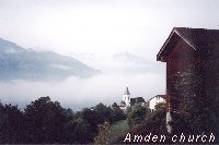
Amden
Quinten is an attractive wine-growing village, with the distinction of being the only village in Switzerland with no road or rail access. I’ll leave a description to the book. There is a short climb out of the village, then we headed west on a level path for a while before making the steep ascent which takes you over the top of the cliff which drops vertically to the lake. We were both hot and tired, and going slowly. When the descent came at last, a good, well graded wide path drops almost to lake level. Then the final climb to Amden started. Again the path is steep, and although at the half-way point the contours say the gradient eases, our tired legs didn’t really notice. I found the last bit of road up to the top of the village really exhausting, just managing to plod on without stopping, then hobbling down the main street to the hotel.
| ascent | descent | time | distance |
|---|---|---|---|
| 800m | 1705m | 8h50′ (inc. 2h stop in Murg) |
* Sadly after all Jonathan’s effort the intended book didn’t get beyond the first few chapters, as real life and the need to earn a living had to take priority.