Berner Oberland 2002, part 2
Finsteraarhorn
Day 4 – Monday 29 July
Early
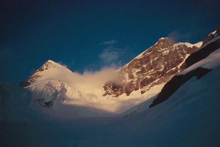
I mentioned that I’m not at my best with early starts. I’m even less at my best when the start is directly and steeply uphill – I just don’t seem to get going. At least, that’s how it was when we left the hut at 4.35, with the aim of the Finsteraarhorn by the normal route.
I was struggling right from the start. Chris and John set a moderate pace up the rocky path from the hut terrace, but I quickly fell behind. They waited where the path levels off at the site of the old hut, and we kept more or less together over the next section of less steep rock. Reaching the glacier we roped up, and as usual I took the lead to set a pace I was comfortable with.
We carried on steadily up the glacier across snow and ice patches, but although the conditions were fine I was finding it hard going. By the time we reached the small bergschrund below the rock rib which forms the SW ridge of the mountain and climbed the short distance to the col at 3636m (known as the Frühstückplatz, or Breakfast Ledge) we’d been going 2 hours and I was feeling pretty tired. By now we were last on the mountain.
Back
Neither of the other two said anything, but we looked at the next section – a steep snow slope up to the Hugisattel, a col on the NW ridge at 4088m. “How long should it take?”, I asked. We reckoned about an hour and a half to stay on guidebook time. “Can’t do it”, I said. “You go on, I’ll go down. We’ve seen the route, and it’s perfectly OK to solo while it’s still freezing.” I stayed to watch them set off, and then made my way back down.
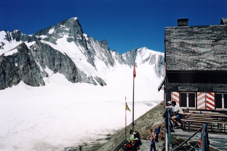
Finsteraarhorn hut terrasse – Grosse Grünhorn behind
Down
Later, I was sitting on the hut terrace in the hot sunshine, keeping an eye on the path down. Chris came down first at a half run, too quick for me to get a photo as he passed through the stone columns which form a portal to the route. But I caught John a moment or two later. They’d done it – John’s first alpine 4000er, and a good one – the highest peak in the Oberland. We had a beer to celebrate.
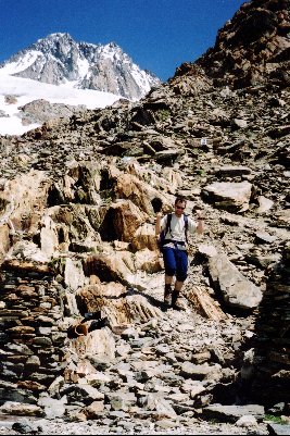
John’s triumphal return
Statistics
| time | altitude(m) | |
|---|---|---|
| Finsteraarhorn hut | 0435 | 3048 |
| Frühstückplatz | 0635 | 3616 |
| Finsteraarhorn hut | 0815 | 3048 |
| Total height gain/loss (m) | +/- 568 | |
| Total time | 3h 40m | |
Mönchsjoch hut
Day 5 – Tuesday 30 July
Conditions
We’d originally planned to go to the Mönchsjoch hut via the Fiescherhorn, another 4000-er. But we’d been asking others at the hut about the conditions, and were getting less confident about the prospect of tackling either of our two possible routes with full packs. In the end we decided to postpone qualifying for Hard Men of the MountainsTM status and take the easier, but much longer glacier route via Konkordia. This would get us to the Mönchsjoch hut with three days in hand, and three summits to do – Fiescherhorn, Jungfrau, and either Mönch or Eiger.
We made a reasonably early start at 0500, crossed the Fiescherfirn as it was getting light, and were at the top of the Grünhornlicke by 0615. The descent to Konkordiaplatz was still in shadow, and we made good time to the bottom. None of us had been to Konkordia before, so we were glad to see one of the places of Alpine legend. We had a good view of the flight of steps up to the Konkordia hut, but decided not to spend time paying the hut a visit.
Diamonds
Konkordiaplatz itself was free of snow, and still frozen as we set off towards the Jungfraufirn. Crevasses in our path were easy to negotiate. As the sun rose higher and moved round we started finding more patches of snow. Where the surface was icy, the sun caused almost immediate melting, and trickles, runnels, and streams of water began to run in every crevice. It was easy to see why Konkordiaplatz has been described as “a swamp” later in the day. But on the snow patches the low-angled sunlight was reflected by a myriad of flat ice crystals varying in size from a few millimetres to a few centimetres across, and we were walking through a field of diamonds.
Although there were some larger crevasses across our path from time to time, there was only one which looked a problem. We scouted left and right looking for somewhere to cross, and although I thought there were a couple of places we could have made it, Chris and John kept looking – and found a bridge! It was two wooden planks end-to-end, with cross-pieces to give an impression of something for boots to grip. No handrail. We belayed each other across.
Further up the Jungfraufirn the route moves towards the centre of the glacier to avoid crevasses and seracs on the right. The dome of the Sphinx observatory is in view. From here on you keep walking, and walking, . . . and the Sphinx never gets any closer!
Chocolate
But eventually we were there, hauling ourselves up the last, and surprisingly steep, few metres to the Jungfraujoch station tunnel entrance. There were already plenty of tourists around. Should we ignore the temptations of the café, and toilets with hot running water? Not likely! We barged our way through the throng with our rucksacks, and settled down with three hot chocolates and a curious pastry (courtesy of John).
Time passed easily. Although Chris and I had been here before quite a few times between us, we’d never been to the observatory. So we went there. Then Chris tried unsuccessfully to send an e-mail from a coin-in-the-slot machine. Then we took a daft photo against an artificial backdrop of the Jungfrau glacier. Then we visited the toilets and had a wash in hot water. At last, with nothing else left to do, we headed back for the exit. 40 minutes later we were at the Mönchsjoch hut.
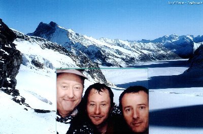
“Kicks over the traces of Hockney’s
post-perspectival obsession” – Brit. J. Post-modernism
“So real you’d think you were there” – Astigmatism Today
Lost
Oh, and if anyone finds my red Suunto Altimax wristwatch/altimeter which I left on the Jungfraufirn after taking it off to put on suncream – and which I didn’t miss until an hour later – please let me know. Otherwise it’ll remain to puzzle archaeologists in a few centuries’ time.
Statistics
| time | altitude(m) | distance(km) | |
|---|---|---|---|
| Finsteraarhorn hut | 0500 | 3048 | 0 |
| Walliser Fiescherfirn | 0510 | 2970 | 0.3 |
| Grünhornlicke | 0615(a) 0630(d) |
3280 | 2.5 |
| Konkordiaplatz | 0730(a) 0740(d) |
2730 | 5.5 |
| Jungfraujoch station | 1135(a) 1345(d) |
3420 | 13 |
| Mönchsjoch hut | 1425 | 3657 | 15 |
| Total height gain/loss (m) | +1237 / -628 | ||
| Total time | 6h 50m | ||
Watching the Jungfrau
Day 6 – Weds 31 July
Weather
We’d been lucky with the weather so far. The high pressure that had arrived while we were at the Oberaarjoch hut had stayed with us. But towards the end of yesterday afternoon (Tuesday) things changed. A high haze turned into cloud and thunderclouds billowed up over the Jungfrau and Mönch from the Lauterbrunnen and Grindelwald valleys. We didn’t get a thunderstorm, but it was drizzling and murky as night fell.
Up at 0430 and, bleary-eyed, opening the door to the terrace to go to the toilets. Six centimetres of snow! Soft, wet, unfrozen snow. Discussion over breakfast – Jungfrau, or not? The weather looked reasonable – clear, but with some cloud around. Some groups were going to try it, others were deciding not. In the end we hedged our bets – we’d go down to the Jungfraujoch station, have a look at the route, and then decide.
Sunrise on the Jungfrau. (Photo – Chris)
From the tunnel entrance we dropped down onto the glacier and followed tracks towards the start of the ascent. As soon as we moved away from the Jungfraujoch complex we were sinking into soft snow, even on the piste-bashed track. We paused to assess the situation. Fresh snow, no freeze, and we’d already heard one small avalanche somewhere to the south. We all agreed – no Jungfrau today. We’d go a bit further, watch how the other groups were getting on, but not attempt it ourselves.
Grandstand
We watched for a while from near the start of the route, then headed back to the Jungfraujoch, entering at the upper viewing gallery. We sat inside for the best part of an hour with a grandstand view of the parties on the climb, and saw them one by one turn back. We heard later that only one, possibly two, ropes had made it to the top.
Snow
Back at the hut that afternoon the weather closed in again. It was snowing by 1530, and visibility for the rest of the afternoon and evening varied from 50 down to a few metres. It was still warm, and no signs of an overnight freeze when we went to bed. We booked 7 o’clock breakfast.
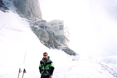
John below the Mönchsjoch Hut
Route note
My edition of the Alpine Club guidebook Bernese Oberland Selected Climbs, by Les Swindin says
It is sometimes possible (in a very snowy year) to reach the Rottalsattel by ascending SW into the combe directly below the col. The bergschrund below the col is often impassable. This saves about 1hr.
This route was being used when we were there. It looked OK – parties making it to the bergschrund were getting past it near the left side with no apparent difficulty. The only dubious aspect was that any snow- or rockfall from higher up, or from the Rottalsattel ridge, would be funnelled straight down onto anyone on the route in the higher part of the comb below the bergschrund.