Walking the GR221, Mallorca – Day 5
Cúber – Massanella – Lluc
11 October
Stats: ascent 680m; descent 930m; time taken 6h 50′
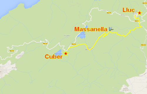
Mallorca’s highest peak, Puig Major, has military hardware installed on the summit and is not open for public access so aspiring peak-baggers have to be satisfied with climbing the second-highest mountain, Massanella. This lies conveniently close to the GR221 and was our objective for the day. Jonathan and Nicky opted for a rest day – a bus ride into Pollença – so it was four plus Jaume who rode back to the car park at the Cúber reservoir to start where we left off yesterday.
We followed the GR221 faithfully, at first level alongside a man-made concrete water channel then up through forest, over a small col, briefly downhill, then up again heading north-east on a clear track. As we got higher the forest gave way to low shrubs and coarse grass. For the first time this week there were wisps of mist and Massanella’s south-west ridge to our right was hidden in low cloud.
Jaume was looking out for a side track. Having spotted it he explained the plan: the narrow track would take us up onto the south-west ridge which we would cross, then follow a path below the ridge line until finally rejoining the ridge for the final ascent to the south-west summit. From there it was a short almost level walk to the main summit a few hundred metres away. We set off up the hillside, Jaume complaining that the daubs of blue, yellow and white paint on the rocks were unnecessary, unsightly and potentially misleading. Worse still, they’d been done by people outside his circle of unofficial path wardens. He started planning to return in the winter to chip them off.
At this stage our descent route was still undecided. The quickest way would be back down to a point just below the ridge on this side and then a path back to the GR221 near its highest point. The alternative was a long loooping route north-east and then west which came out near Lluc. Above the junction with the shorter path we scrambled up some limestone slabs which were already slippery in the damp mist – too slippery for a safe descent when there was a less risky option. It would be the long route down.
Although the mist persisted on the far side of the ridge the rock was dry and the final scramble to the top was easy enough. We took the obligatory summit photos.
The descent was uneventful but long. We stopped for a late lunch break in the only muddy section of the whole week’s walk. Otherwise the constant stony ground was unrelenting and hard on the feet and knees.