Walking the GR221, Mallorca – Day 3
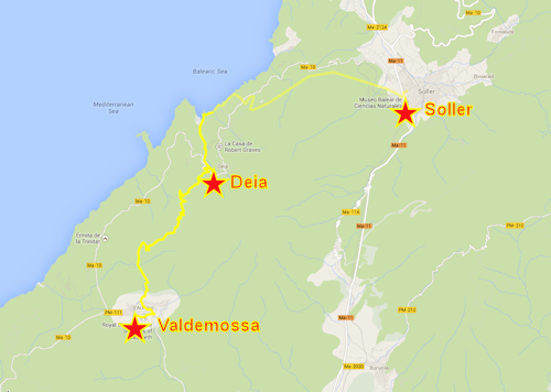
Valdemossa – Deià – Sóller
9 October
Stats: ascent 960m; descent 920m; time taken 8h 15′
We were back in Valdemossa soon after 9.00 the next morning and had time for a short walk round the old part of the town. The place is devoted to their local saint, Santa Catalina Thomas. As well as a modern sculpture in a corner by her shrine, every house in the old town has a decorative tile set in the wall by the front door, asking for the Saint’s prayers.
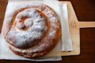
Equally if not even more interesting to us was the baker’s shop. We’d been looking forward to buying some fresh bread as the wholemeal loaves we’d each been given on Sunday were getting very stale and dry. We bought bread and the local speciality pastries, ensaimadas, a sweet, light, flaky whorl sprinkled with icing sugar.
We didn’t stay too long as we had a long way to go. Both stages of our walk today were each a normal day’s hike. Deià was our first objective: we planned to have a break and refreshments in the new ‘mountain’ hut (it’s in a valley less than 100m above sea level).
Leaving the town we headed uphill. By now we were getting used to the rough stony tracks – stones ranging from pebbles to cobbles with a few small rocks and boulders for good measure. We each automatically tried to pick the easiest route.
Uphill continued for a long time. At a gate at a junction we met a young German couple with full hiking packs going our way. Jaume spent several minutes giving them detailed route instructions, and we soon saw why. The next section was barely waymarked – soon after the gate the route turned abruptly off the track on a vague path which meandered uphill through the trees with many changes of direction, finally emerging onto a wooded plateau. In any direction all we could see were trees. Paths, or not paths, seemed to lead off in all directions. In a clearing a rough circle of logs had been arranged near a charcoal burning site. We stopped for a mid-morning break.
On again, level for a while then a final uphill section which brought us out of the trees on a rocky outcrop. A ridge continued to the north-east. We were at one end of the Cami de s’Arxiduc, the Archduke’s Path, built by Archduke Luis Salvador, a member of the Austrian imperial family who visited Mallorca, fell in love with the island and lived in a fine house between Valldemossa and Deià between 1867 and 1915. The path named after him is a paved track he built, wide enough for him to drive in a carriage enjoying the views.
All morning Jaume had been promising us lunch ‘on the Edge’. This turned out to be the point where after leaving the Cami our route descended a little and brought us to the top of a 600ft cliff. The views were amazing.
After lunch it was down. And down. And down. The path at first found an improbably steep route down the cliff, then as the gradient eased slightly it plunged (Jaume’s word) into the forest. A commotion above our heads turned out to be one of the island’s feral goats looking for a way off a ledge about 15 feet above. Our presence panicked it and after darting to and fro a couple of times it launched itself into the air over our heads, crashed to the ground ahead of us and ran off apparently unhurt to join the rest of the small flock which we now saw in the trees below.
Eventually the forest gave way to richer vegetation and signs of cultivation but it was still a good half hour’s pushing through tough overgrown bushes and grasses before we hit a tarmac road on the outskirts of Deià. Another ten minutes and we were sitting on the terrace of the GR221 refuge ordering drinks. It was 2.15 and we still had another standard day’s hike to do!
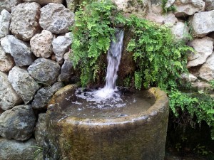
Fountain in Deià
* * * * * * * *
Half an hour later we were rested and ready to leave. Clive though had been disappointed not to have done more exploring of the local villages, and feeling he’d walked enough today decided to spend a bit longer in Deià and get the bus to meet us in Sòller. Gerry volunteered to keep him company.
Jaume opted to take us on the coast path for the next section. Jonathan and I had walked this section of the GR221 two years before, following a higher line which we would join later. From the little cove of Cala de Deià we were on Jaume’s home territory – he had lived in Deià for many years and this section of path was ‘his’. He wanted to show us all the best viewpoints, and was annoyed to find some landowners trying to block the route he had laid out. Tree branches and rocks were moved from one track to another as the correct line was restored.
Note: somewhere around here I turned off the GPS tracker on my phone. The battery was getting low and I needed to preserve what was left in case we needed to contact Clive and Gerry, who should be waiting for us in Sóller. I added this part of the track on today’s Google map by hand later.
We followed the coast as far as the hamlet of Llucalcari, then turned up the hillside. It was mid-afternoon now and hot in the full sun as we climbed from sea level across the main road and higher onto the GR221 path. The path was more undulating than Jonathan and I had remembered, and I was getting tired. A short tea break (water, a biscuit and the remnants of some chocolate) revived me a little, but the final miles along the track and then downhill on a cobbled lane into Sóller were hard going. I lagged behind and Tony G dropped back to keep me company.
We’d told Clive and Gerry to wait at the bus stop and expect us aboout 6.00. By now we had regrouped and at 5.59 we turned the corner and saw the two of them looking up the road towards us. Even I managed a slight swagger as we finished the last hundred metres on the stroke of 6!