Zermatt to Monte Rosa – the Italian High-level Route 1999
Prologue – Weissmies (almost)
15/16 July
Looking back, soloing my first ever Alpine 4000m as an acclimatisation exercise was perhaps just a little ambitious.
I left Saas Almagell (1680m) and walked up to the Almageller Hut (2894m – 3hrs). Setting off at 4.40 next morning to climb Weissmies (4023m) by the SSE ridge (PD), I followed several other groups up to the Zwischenbergerpass (3268m) on a cairned track, reaching the pass in just under 1 hr.
The snow field on the E side of the ridge was in good condition. It was a clear morning, with great views S to the Portjenhorn and Portjengrat in the sunrise. I zig-zagged up the snow, then followed others onto the rocky part of the ridge. Here doubts begin to set in. Everyone else was roped up, and the rock was still icy in places. Some people opted to climb the ridge in crampons, others took theirs off. I chose to take mine off, and made reasonable progress up the first part of the ridge. But there were a few places where scrambling turned to climbing, and I began to feel uncomfortably exposed. It would have been good to have had a (human) friend and a rope with me.
After the third difficult section I started to think about getting down safely, and realised I felt completely exhausted. The ridge continued steeply above with no sign of the top. I decided to sit down for 10 mins, munch a fruit bar, and see how I felt after a rest. The last of the other parties surged on. It was getting a bit late, I was dropping behind guide book time, and morale was low.
After the rest, discretion won and, making sure no-one was around to see, I retreated. I made up for the disappointment by doing some long bum-slides (a technical term for controlled glissades) down the snow field. Taking my time I walked down to the hut, had a break, and finally trekked down to Saas Almagell.
Studying the map afterwards I reckon I made it to about 3800m, so I only missed by just over 200m. Still, as someone said later, “The mountain will still be there next time, and this way so will you.” (I went back next year. This time I had an altimeter. My turning-back point was at 3835m. Oh well!)
Day 1 – Zermatt to Gandegg Hut
18 July
Stats: Ascent: 597m; descent: 0; max. altitude: 3029m
Weather: am – sunny and warm; pm – cloudy, thunderstorms.
Introductions first. We didn’t call ourselves the Glacial Erratics until later, but here we are – four aspiring mountaineers and our guide.
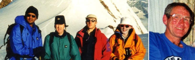
‘Kodak’ (Udai), ‘BOF Vader’ (Tony), ‘Mr Cool’ (Chris), ‘The Ghost of Monte Rosa’ (Duncan) and ‘Uncle Alan’ (Alan Kimber)
Chris, Duncan and I had met after we’d booked this trip, but we’d not climbed together. We’d exchanged e-mails with Udai, and met him for the first time the day before we set off. He had been a client of Alan’s in Scotland.
We had all been staying in Saas Grund, so the first morning we drove round from Saastal to Mattertal, left Alan’s car in Täsch, and took a taxi into Zermatt. We walked through the town and took the gondola and cable car to Furgg.
Top Tip
How to look cool walking through Zermatt
Do
- ignore all the Japanese tourists
- nod to anyone wearing a UIAGM badge
Don’t
- stop to tie your bootlace
- drop your ice axe
- buy postcards
- trail a loose end of rope out of your rucksac
- open your rucksac to check that you remembered to pack your crampons
From the cable car station at Furgg (2432m) the path to the Gandegg Hut (3029m) winds its way first up a vehicle track, then through a series of stony corries, passing under the Trockenersteg cable car. We lunched on the way and reached the hut in 2hr 10min.
Alan dragged us out of the comfort of the hut later in the afternoon for a first practice of roping-up and catching falls, but his efforts were thwarted by a thunderstorm which drove us back inside to watch the lightning through the thick mist.
Day 2 – Gandegg Hut to Ayas Hut
19 July
Stats: Ascent: 797m; descent: 432; max. altitude: 3826m
Weather: sunny and very warm all day.
This was the first day we spent entirely above the snow line, and our first experience of glacier travel.
We left the Gandegg hut at 0535, and followed the well-bashed ski piste up the Oberer Theodulgletscher to the Theoduljoch and the Plateau Rosa, as far as the col at 3826m. The first skiers descending from the Klein Matterhorn station passed us around 0900.
Top Tip
When a roped-up party crosses from one side of a ski piste to the other, it is a good idea to make sure there are no skiers approaching.
We stopped before the col for more crevasse rescue practice, this time taking it in turns to jump off a 5 metre ice shelf to be caught by the others and hauled out – except for Udai, who seemed to think the aim was to stay down there and dig in.
Now my day was plunged into misery. I realised I had lost a small piece of plastic and rubber – the nose-piece on my sunglasses. Failing to find it after a full search, I spent the rest of the day with my glasses resting so close to my face that they were constantly smeared by suncream and sweat. I travelled the remaining distance in a foggy blur.
We moved onto the Breithorn plateau and debated whether to climb Breithorn. The consensus was “no”, so we continued across the plateau in bright, hot sunshine with the snow getting increasingly soft, and finally descended the Grande Ghiacciaio di Verra to the Ayas hut (3394m), arriving at about 1400.
The Ayas is a nice friendly hut, with a real washroom and a Gaggia coffee machine. Alan was tempted to get us prussiking up a rope off the balcony, but decided in the end the hut guardians might not approve, so we passed the afternoon drinking tea and coffee in the comfort of the hut. I spent a useful half hour making a new nosepiece for my sunglasses out of small bits of sticking plaster, a repair which served well for the rest of the trip, and which added further style to the cool and fashionable look for which our group was already establishing a reputation.
Top Tip
Amuse your fellow climbers by using one of those black and yellow Charlet Moser crampon bags that are this season’s “must have” as a charming sponge bag for your washing kit.
Day 3 – Ayas Hut, Castor, Quintino Sella Hut
20 July
Stats: Ascent: 827m; descent: 636; max. altitude: 4221m
Weather: cold and clear to start, then windy with some light mist, turning cloudy later.
We left the Ayas hut at 0535. We would have left earlier if my harness hadn’t developed a mind of its own overnight and formed itself into an unfathomable topological puzzle.
Top Tip
Avoid ridicule and the pitying looks of others by putting your harness on before breakfast instead of in full public view. If that doesn’t work, sleep in it.
We followed the normal route up the Verra glacier and onto the WNW face of Castor. The bergschrund was almost non-existent, and we crested the summit ridge at its lowest point.
We were not alone. There were at least 15 people on the summit arète, in three or four groups, heading in both directions. The arète itself is very narrow – one boot-width – with steep snow slopes either side. We turned left (NW) and occupied the secondary summit (4205m). We took photos. Udai took more photos. Duncan topped up his sunblock.
Once the traffic had died down, we traversed the ridge to the main summit. A strong wind was blowing from our right (SW), fortunately steady rather than in gusts. The exposure felt considerable – though objectively it wasn’t particularly severe. We joined about 10 others on the summit (4221m) – our first 4000m-er! Our time from the hut was 3h15m.
Of course, a thin mist came down immediately, which along with the crowd and the strong wind made the summit a place not to linger. We headed down the SW ridge on still-frozen snow as far as the col, where we took the official 4000m team photos and Duncan had time to top up his sunblock. Then down the Felik glacier to the Quintino Sella hut (3585m), arriving about 1200.
Alan got his way at last, and we practised placing buried axe and ice screw belays in the glacier near the hut, then rigged up a rope on a nearby boulder and took it in turns to prussik up. Points out of 10 were awarded for competence and overall style.
- Chris 11.3/10 (extra bonus points for being cool)
- Tony 7/10
- Duncan 4/10 (points deducted for getting sunblock on the rope)
- Udai 1/10
Day 4 – Quintino Sella Hut via Naso & Piramide Vincent to Gnifetti Hut
21 July
Stats: Ascent: 780m; descent: 754; max. altitude: 4215m
Weather: perfect all day!
Off at 0545 on a fine clear morning with a strong, cold wind. We headed back up the Felik glacier, passing between points 3744 and 3846, then contoured in a northerly sweep on the Lys glacier under the S face of Liskamm.
We stopped for a break at the far end of the traverse where the route steepens at the foot of Naso del Liskamm. Here we had a dramatic view of a cornice collapse from the Liskamm ridge, sending a fair-sized avalanche down the S face about a kilometre from our position and filling the air with ice powder. When the air cleared we could make out a climber on the S face just below the ridge. The figure slowly made its way back onto the ridge, where a second figure appeared, presumably from the other side. It seems we had witnessed a classic “if I go off this way, you jump off the other” incident. No rescue helicopters appeared, so we assumed everything was OK.
Our route took us over the Passo del Naso. The bergschrund on this side was a simple step, then the route made a steep rising traverse in a couple of zig-zags across the even steeper slope of the Naso. At one point floods of ice crystals blowing down the slope in the strong wind filled the trench of the path, so that we were wading ankle deep in loose grains of ice.
We reached the top of the pass (4150m) and stopped for a breather and photos before tackling the descent – almost as steep – back onto the Lys glacier. The bergschrund this side proved a bit more fun. I was in the lead (Alan always took the high end of the rope) and slithered over the drop facing out – the others faced in and stepped down more or less elegantly. In Duncan’s case it was definitely less, as he had jammed his crampons together when he turned round, and couldn’t move his feet.
Still going E we headed across the top of the Lys glacier for Piramide Vincent (4215m), which we climbed by the easy snow route up the NNW flank. We reached the top at 1045, 5 hrs from the hut.
We retraced our route down to the glacier, and descended past some impressive seracs to the Gnifetti hut (3611m), arriving at 1200.
Day 4 – Interlude
21 July
The Gnifetti Hut. It was here that Udai slept in a cupboard, and Duncan won a Blue Peter badge for making a photographic dark room out of three blankets and a black bin liner so that he could retrieve the end of a roll of film that had accidentally rewound itself when he pressed the wrong button on his camera. Amazingly, it worked!
The prize for oddball-of-the-week, though, went to an Italian with a top of the range mountain bike which he had backpacked up from the nearest cable car, and who apparently intended to take it up to the Margherita Hut the next day and ride down from there. We never saw him again.
It was here, too, that our plans for Monte Rosa almost fell apart. We were planning to spend the next night in the Margherita Hut (you know, the one on the summit of Signalkuppe, highest in Europe, etc etc). The problem was that when Alan phoned to book us in, he was told the hut was full. We discussed alternative Plans B, C, and D, all of which meant missing out at least one of the summits we had planned. The final choice was left to the morning so we could see what the weather was like.
In the morning a quick discussion settled on Plan C. We would make a fast time straight to the Margherita Hut, leaving out Parrotspitze, and hope that by arriving early we could bag any spare beds that came available during the day.
Did we make it? Find out in the next exciting episode of “Five Go for a Walk in Lots of Snow”
Day 5 – Gnifetti Hut, Signalkuppe (Margherita Hut), Zumsteinspitze
22 July
Stats: Ascent: 1087m; descent: 169 max. altitude: 4563m
Weather: perfect all day again, though near gale-force wind at times on Signalkuppe.
Despite Alan’s increasingly scathing comments, we still couldn’t manage to get away from the hut before 0545. We set a cracking pace up the Lys glacier, especially while we were under the seracs, and made the Lysjoch (4248m) at 0730 just as the sun was coming up. Views W to Liskamm, with the Matterhorn peeping out behind, were fabulous and we all took loads of photos.
From the Lysjoch we carried on across the Grenzgletscher to a point near Colle Gnifetti, then turned up to the Margherita hut on the summit of Signalkuppe (4554m). It was 0900, making 3¼ hours from the Gnifetti hut.
Negotiations with the friendly, charming and hospitable people who run the hut got us an agreement that if there were any cancellations, we could have beds, and if not we could sleep on mattresses on the kitchen floor. That was good enough for us, and we spent the next couple of hours in serious tea-drinking mode.
Around 1100 Chris and I started to get restless. We started muttering about Zumsteinspitze, which had been part of our original plans, and was temptingly close across the col from the hut. Despite the gale blowing outside, which ripped the hut’s Italian flag to shreds in the course of a few hours, the others agreed, and we set off at 1130. We dropped back down to the col, and took the facing SE ridge to the top of Zumsteinspitze (4563m), which was the highest point of our trip. Back to the hut by the same route – round trip time about 1½ hours.
And, great joy, we had beds! The rest of the afternoon was variously spent
- sleeping (Alan)
- ranging around, buying postcards, writing postcards, unpacking rucksac, packing rucksac (Duncan)
- taking photos (Udai) (and Duncan)
- looking cool reading a German climbing magazine (Chris)
- eating soup and bread, sitting staring into space, sleeping (me)
Top Tip
At this level of achievement, everyone has the greatest respect for each other, and the camaraderie of the mountains is a joy to experience. Those tall, tanned, athletic young men with UIAGM badges are local guides. They’re really quite shy, which is why they are talking to those young women about a party tomorrow night in Zermatt. They would much rather be talking about serious mountaineering matters, so why not break the ice? Go over and say hello, and tell them why, in your experience, Ron Hills are so much better than the black salopettes they are all wearing. You’ll be amazed at their response!
During the early evening clouds formed on the Italian side of the mountains, on which we were looking down with a clear sky above. During the night the cloud cleared and we could see the lights of Milan in the far distance 4500m below.
Day 6 – Margherita Hut via Grenzgletscher to Zermatt
23 July
Stats: Ascent: 215m; descent: 1954; max. altitude: 4554m
Weather: fine and clear, becoming hot by mid-day.
Lazily, we didn’t leave the hut until 0600. Our objective for the day was clear – all the way down the Grentzgletscher to the Gornergrat, and the train down to Zermatt.
We followed the normal route down the glacier which, facing generally W, was in shade most of the way, so we made good progress on crunchy ice. The going was good most of the time, though there were 3 or 4 steeper sections with significant crevasses and seracs which needed a bit more care. The day was clear, with little wind.
The descent was uneventful. We left the glacier at or near point 2907 to pick up the path on the lateral moraine past the Monte Rosa Hut. After passing the hut, the path drops steeply down onto the Gornergletscher (iron ladder rungs in the rock) which we crossed on ice and rubble to join the path along the S side of the Gornergrat. By this time we were in full sun, and the day was hot. The long descent seemed to have locked my legs into downhill mode, because I had great trouble dragging myself up the short but steep climb from the glacier to the Gornergrat path.
The path climbs gently along the face of the Gornergrat, leading to Rotenboden station on the Gornergrat railway. Our time to the station was about 6½ hours.
And finally, down into Zermatt on the mountain train. It was strange to see green again – like grass and trees – after a week of ice, snow and rock. And to see people who weren’t mountaineers – like the Japanese tourists on the train who chatted to Udai. We tried to sell him to them: “He’d make you a fine son. He’s a doctor.”, but they said they already had one at home. Then it was ice-creams (and postcards for Duncan) in Zermatt, back to Täsch and Alan’s car, Saas Grund, and showers!. And a few beers that evening . . .