South West Coast Path – Day 10
Hartland Quay to Morwenstow
6 June 2023
Distance on Coast Path: 12.7km; ascent 655m
Total distance: 13.4km; ascent: 655m
Walking time: 3h 54′
Total time: 5h 00′
Overnight: The Bush Inn
“If you know, you know”, goes the expression. It’s hard to say why the downs-and-ups of this stretch of coast are so exhausting, but if you’ve walked it you’ll know. According to the guidebook Hartland Quay to Bude counts as one stage, but “this is probably the most arduous of all the days in the suggested itinerary. It is necessary to cross ten river valleys … all of them steep and deep.” The statistics from the book: distance 24.5km (15.2 miles); ascent 1271 metres (4170 feet). In comparison, walking from Fort William to the summit of Ben Nevis and back would be about 17km and 1340 metres – not as far and with only slightly more height gain.
So while the individual downs and ups are not long, with rarely as much as 150 metres of ascent/descent, once you reach the first of them they are relentless. The path is always steep, sometimes with uneven and irregular man made steps with wooden risers and eroded treads, sometimes in narrow gullies with loose gravel and pebbles underfoot, occasionally re-routed and recently laid where the original path has had to be abandoned due to cliff-fall or path erosion, but never easy. There’s never a time to relax while you’re moving.
There’s a psychological effect too. When you are on the high ground the way ahead looks so simple – gently undulating fields stretch ahead seemingly all the way to Bude. A hundred paces later the ground opens up beneath your feet as you come to the lip of another hidden valley, another down-and-up invisible until you are right on its edge. It’s tough. And I was so glad I decided I didn’t need to beat myself up by trying to do the whole distance in one go because as the guidebook says, “many may prefer to split the length at Morwenstow where … the pub also offers some accommodation.”
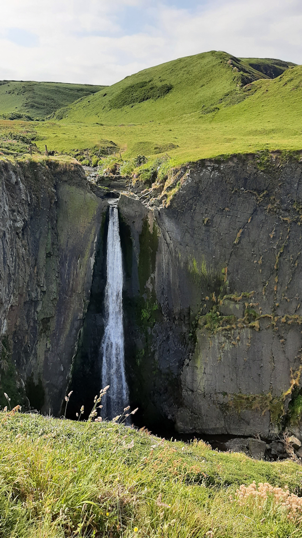
The waterfall at Speke’s Mill Mouth
I allowed myself a leisurely start, eventually setting off at 9.30. Sophie was aiming to reach Bude and had traded breakfast for a packed lunch which was left in a small fridge at the hotel reception so she was long gone by the time I left. The day got off to an easy start – a short uphill, the first drop and back up again, then the second valley at Speke’s Mill Mouth with its impressive waterfall.
The waymarking of the Coast Path had been very good so far (except for Ilfracombe), but either I missed something or it needs one or two more markers at this point. An unmarked path led to the right off the access road and over a bridge to a T-junction. An old wooden sign partly obscured with lichen pointed left, with the legend “Coast Path (Valley Route)”. There was no sign to the right. That evening I saw the SWCP guidebook recommends the valley route, but that was no help at the time. The Valley Route led away from the coast so I stuck to the plan: “Keep the sea on your right” and took the unmarked path to the right. A kestrel was hovering over the valley. My path rose steeply up the very edge of the cliffs, then more gently for another kilometre or so before a sign marked the point where the Valley Route joined from the left.
The next 5 kilometres was easy high-level going. It was deserted apart from one man dressed for running who I saw first heading north then passing me going back south. It felt very remote and a long way from home.
Eventually I reached the drop to next river valley, Welcombe Mouth, where there is a car park but no services. The next valley, Marsland Mouth, follows almost immediately; my heart sank as I saw a flight of what must be more than 200 earth-and-wood stairs built in a direct, straight line down the side of the valley. As I’ve said before, these man-made steps are uneven and uncomfortable though arguably better than a steep path with a loose surface. I jolted slowly down and didn’t count.
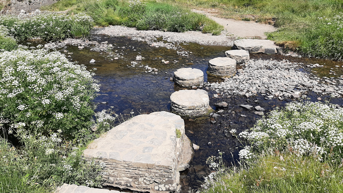
Stepping stones, Marsland Mouth
Marsland Mouth
On the bright side, Marsland Mouth marks a significant point in the Coast Path – the Cornish border.
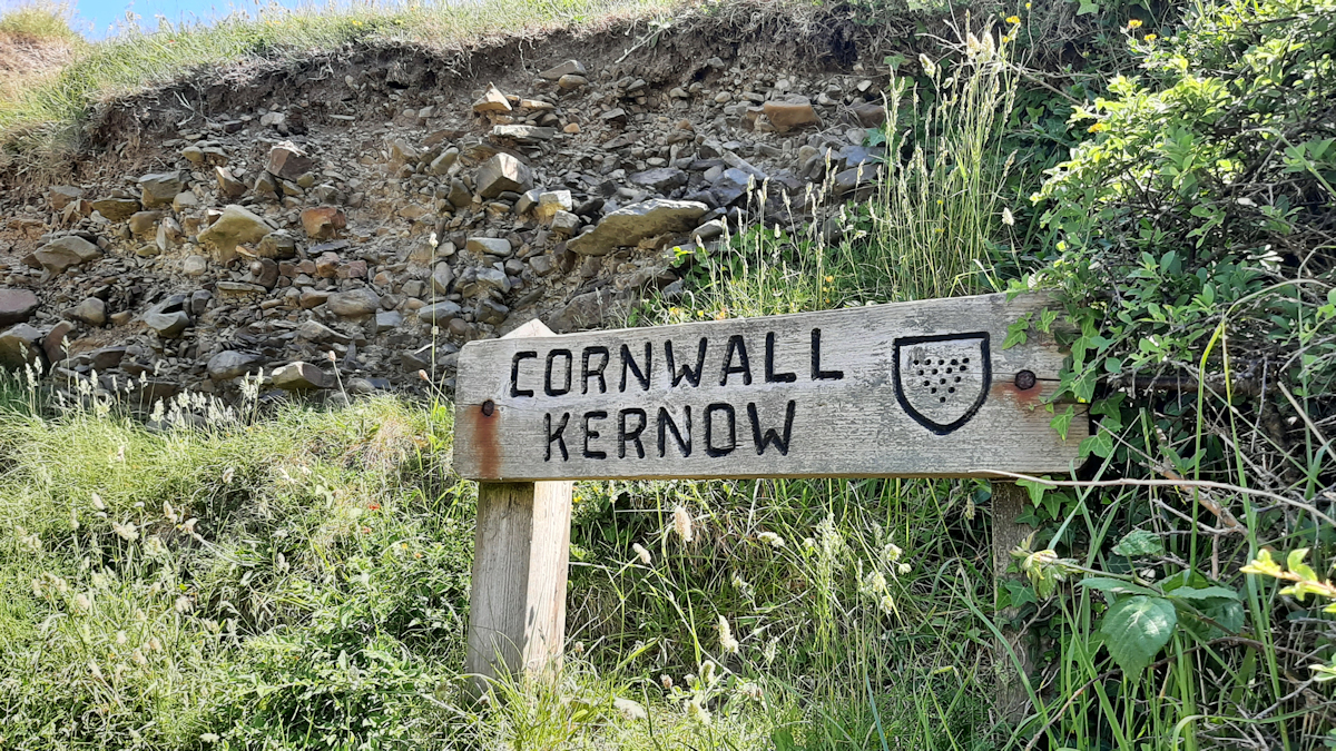
Border crossing
Up from Marsland Mouth, down (unnamed), up, down again (Yeol Mouth), up again. By this time I was tired and moving at a snail’s pace. I wanted to get to Morwenstow, rest and refresh. And reaching the top of a small rise, there was Morwenstow Church looming hugely, less than half a mile away. Ten minutes and I’d be there. But wait! What? Oh no! It’s the other side of another down-and-up!
So it was down to the stream (surprisingly unnamed on the OS maps) and a slow haul up the other side. Leaving the Path at the top I trudged the final level half mile or so to Morwenstow and the Bush Inn, completely done for the day.
Geologists – how do such small streams cut such steep, deep valleys along this coast?
Comments
South West Coast Path – Day 10 — No Comments
HTML tags allowed in your comment: <a href="" title=""> <abbr title=""> <acronym title=""> <b> <blockquote cite=""> <cite> <code> <del datetime=""> <em> <i> <q cite=""> <s> <strike> <strong>