Oxford Canal Walk – Leg 3
24 May 2017
Access: Start – drive to Banbury and park. Finish – arranged lift from Marston Doles back to Banbury.
44 – 55km Banbury – Claydon summit
On what turned out to be the warmest day of the year so far I was back at Castle Quay in Banbury to continue walking the Oxford Canal from Oxford to Coventry. My original plan to complete the walk in 2016 fell through, but I’m not in a hurry.
Banbury is expanding. New housing and new commercial estates are springing up north and south of the town centre, but despite this the canal is peaceful as it makes its way north. Where I’d expected a repeat of the factories and yards I’d passed a year ago when I was approaching from the south there was only greenery. I had occasional glimpses of industry through the trees, but apart from a short noisy stretch alongside the A423 all was tranquil and quiet. With the canal on my left the towpath was in shade, and the thick, mature hedge kept the sun off until well into the day.
On the outskirts of town a new development on the opposite bank loomed incongruously over the canal; a series of grey, windowless buildings whose architecture said “Here is power. Keep away.” It was only at the end of the day as I was being driven back to my parked car that I saw it was an amazon distribution centre. Shortly after I passed under the M40 for the third and last time.
From here to Cropredy is pleasant going. The canal is never far from the River Cherwell but with the thick hedge on the right you don’t see any scenery on that side. I only noticed the Cherwell once when it was just a few steps away. Pushing through a small gap to take a picture I came across a swan with her cygnets calmly floating on the river.
I met an elderly gentleman at Cropredy Lock. He was launching a small dinghy with an outboard motor. He told me he and his wife had travelled all over the country in their narrow boat, and after she died and he got too old to handle a large boat he now used the dinghy for short journeys up and down the canal. I took the opportunity to ask if he knew what the black-and-white ‘DS’ markers I’d seen from time to time were. He told me the markers actually read ‘DIS’, and they were distance markers.
Their significance goes back to the days when time meant money working the canal. If a boat was heading, say, south towards Oxford the boatman might send the ‘wheeler’ on ahead to make sure the next lock was full and ready for the boat. If the lock was empty and ready for northbound traffic this meant ‘turning’ the lock. But if another boat was coming the other way, turning the lock meant a delay for the northbound boat, and fights could and did break out. The distance markers were installed either side of every lock; any boat ‘inside the distance’ had priority over another approaching from the other direction and the lock could not be turned against it. That at least was the theory. It has the ring of truth, and I believed him. (See also this discussion on a canal enthusiasts’ discussion board.)
[Note added later: This extract from an authoritative history of the Oxford Canal confirms the explanation:]
Extract from Compton, Hugh J; ‘The Oxford Canal’, pp86 – 87. Pub. David & Charles, 1977
The bylaws of the Oxford published in 1808 contained no less than thirty-three clauses which covered a multitude of sins and J Dunsford, the clerk to the company, required all the staff to see that they were obeyed and if not they were to report the facts to the local magistrate and only in cases of doubt or difficulty was the felony to be reported to him or Mr Tawney.
These clauses covered the usual items, such as name of owner on boat, provision of gauges on sides determining tonnage in boat, stating where contents were destined and correct operation of locks. In the latter connection, to avoid waste of water, boats within 200yds of a lock with the water level right for their entrance were to be given preference. In later years to avoid dispute, metal plates with the letters ‘DIS’ were set up at the stated distance from the locks.
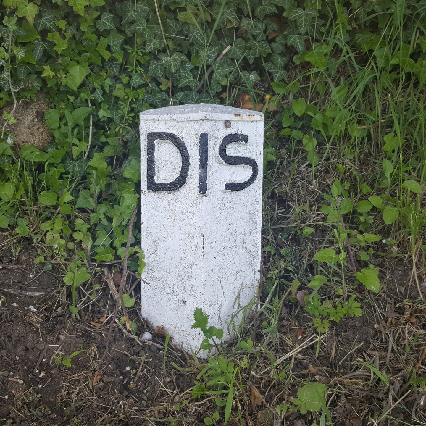
Distance marker
Cropredy is significant in the Oxford Canal’s geography; it’s here that the canal and the River Cherwell diverge (well, technically converge) as the river flows in from its source to the north east. For another mile the canal keeps company with the Highfurlong Brook, a tributary of the Cherwell, which flows out of the Boddington Reservoir to the NNE and of which more later; but soon the canal and the brook are separated by a low ridge and part company. However the other companion, the railway, is still not very far away to the left.
Just north of Cropredy is a vast marina with 249 berths. Opened in 2013 it was too new to be marked on my OS map. In October 2016 the owners won planning permission for an extra 100 berths.
There were many more boats moving on the canal than I had seen last year; most locks seemed to have a boat going through. My pleasant stroll continued until I reached the highlight of the day – the flight of five locks at Claydon which raise the canal to its summit. There was even some mild congestion here.
55 – 74km Claydon summit – Marston Doles
At a dizzy elevation of about 110m above sea level the canal and I had ‘climbed’ about 50m since leaving Oxford. Now starts the ‘Eleven Mile Pound’: from here to Marston Doles the canal is dead level. There are no locks. My highest point would be the bridge where the towpath crosses from one side of the canal to the other.
This stretch is notable for the great loop the canal follows to get round the slight elevation of Wormleighton Hill. About 1.4km from the top lock there’s a point where a crow flying due north would meet the canal again in 3.7km (2.3 ml). To get there by the canal path a walker must travel 11km (6.9 ml) – three times the distance – in the process going in literally every direction of the compass. Resisting the temptation to cheat I pressed on.
Just here too the map shows a ‘dismantled railway’ tight against the canal and towpath. Across the old industrial Midlands there’s a whole network of old railway lines long since disused and dismantled. This particular one is the relic of the prosaically-named East and West Junction Railway which ran between Stratford-on-Avon and Green’s Norton near Towcester. It opened in 1873 and had a faltering history, merging with other companies and finally closing in 1964 (see here and here for more information).
Just at this point a numbered canal bridge, no. 142, does not span the canal but takes the towpath over an overgrown channel. The bridge is identified as ‘Feeder Bridge 142’. There’s no sign of the railway, but the bridge (see photo) is surely too solidly built just to carry a towpath. It must have carried the railway over the feeder channel too.
A bit more detective work on the map shows that this channel – feeding into the highest stretch of the canal and needed to keep the level topped up – flows originally from the same Boddington Reservoir that is the source of the Highfurlong Brook which accompanies the canal for a short time north of Cropredy.
After another few hundred metres the canal crosses the county boundary, leaving Oxford for Warwickshire. It stays in this county all the way to Coventry apart from a brief foray into Northamptonshire around the 90km mark.
A solidly built bridge abutment shows where the E&W Junction Railway crossed the canal. At the same point the modern railway swings in and runs alongside the canal through a 2km cutting called “The Tunnel”. The Fenny Compton Tunnel opened in 1776 and was a little over 1km long. Some covering sections were removed between 1838 and 1840, and the rest had been removed by 1870. Now the towpath runs part way up the cutting several meters above the water.
Just after the Tunnel Bridge carrying the A423 over the canal the towpath crosses to the other side of the canal. There’s another significant crossing point somewhere along this section; the canal crosses England’s east-west watershed. Until now all the ditches and streams in the adjoining fields, and all the trickles running over the canal sluices have eventually drained into the River Cherwell and from there into the Thames and out to the North Sea. From here on they drain into the River Itchen, then the Leam, the Warwickshire Avon, the Severn and out into the Bristol Channel. Nicholas Crane would appreciate this, I’m sure.
Not far beyond the end of the cutting is Fenny Compton Marina (a shop sells refreshments). This is where the canal and the railway finally part company after being together since Oxford. A bit further again is the Wharf Inn, the only canalside pub on this day’s walk. I was tempted, but I’d been dawdling. It was already past 2 o’clock and my feet were beginning to hurt. I passed on.
The rest of the walk was frankly rather dull. A mildly interesting feature might have been what looked on the map to be a very sharp bend where the canal almost bent back on itself, but the reality was unimpressive. To pass the time I determined to take a picture as I headed north, west, east and south before reaching the point at the end of the loop where I had been 3.7km due south a few hours ago.
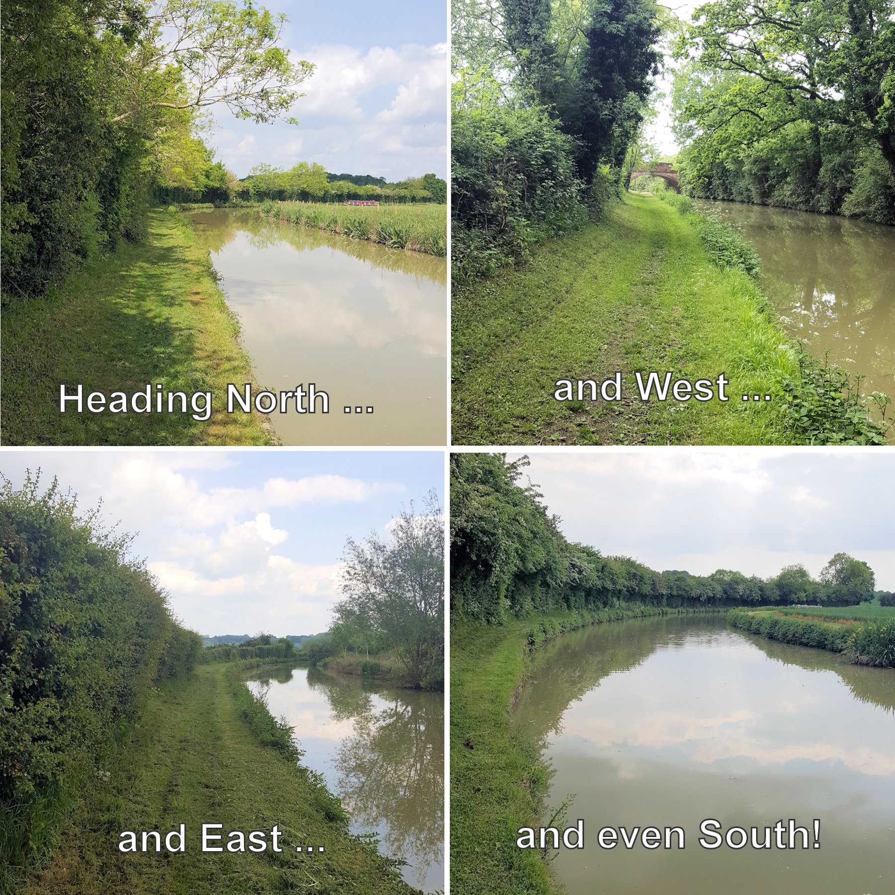
Every point of the compass
With my blistered feet becoming increasingly painful the last 4 – 5 km were a dull trudge. At the end of a final straight stretch I turned a slight bend and found – a lock! Marston Doles Top Lock. The first down lock of the whole walk so far.
Here’s my Viewranger track of leg 3.