
Écrins 2005 – Logbook
On this page is my brief report with the basic facts of the trip and most of the pictures. The Refuges and Huts page has information about the four huts I stayed in or visited. Local Info is just that.
All the pictures on these pages — and more — are shown full-size in the Slideshow.
The link to Souffle is to a long page entitled “À Bout de Souffle”. It doesn’t have any pictures. This week in the mountains was a significant one for me, and here I’ve tried to explain what it was really like — what I was thinking, how I was feeling, and so on. This is a deliberate attempt to break away from the customary rather terse, self-deprecating style of mountain writing where problems are glossed over and personal feelings are ignored. I’ve written it so I don’t forget what it was like, and because hopefully one or two other people who may come across it might find it echoes some experiences of their own.
Arrival day – 16 July
By Easyjet to Grenoble, then by hired car via Bourg d’Oisans and the Col de Lautaret to Briançon, where I contacted Murray Hamilton, my guide for the week, for directions. We arranged to meet at the edge of his village, Les Vigneaux, and he escorted me to the gîte where I was booked for the night.
Refuge du Sélé – 17 July
Murray came to the gîte so we could work out a plan for the week and sort out my kit. He seemed surprised when I mentioned my rucksack weighing over 12 kilos, so we went through it item by item with Murray ruthlessly throwing unnecessary bits and pieces back into my suitcase. I accepted his offer to lend me a lighter headtorch and helmet.
A little later I left the hired car at Murray’s house and we set off in his car up the valley to the car park outside Ailefroide. The path to the Refuge du Sélé heads up the valley of the Torrent de Celse Nière on the north side, at first through trees then in the open. The gradient is easy until shortly before the Refuge, when the river falls almost 300m from the upper hanging valley. The path climbs the same amount steeply (fixed cables in place), then levels out briefly before the track to the Refuge branches off to climb the last 50 metres or so to the hut.
Ailefroide car park: 1514m — Refuge du Sélé: 2511m
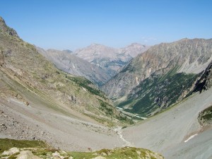
Looking back down the valley from the Refuge du Sélé
Pointe des Boeufs Rouges & Refuge de la Pilatte – 18 July
We went back down to the riverside path and along the almost flat valley. In the dark the profusion of cairns among the boulders is confusing: there is no single best path, and anyway the paths are frequently swept away by the river and landslides. After a while we reached and started to walk up the Glacier du Sélé, generally following its left (our right) side. The lower part had enough grit and stones to walk without crampons, but about 1hr into the journey we put them on.
We moved onto the rocks of the NNW ridge of Pointe des Boeufs Rouges a little to the left of the Col du Sélé, and followed the ridge on good rock. Only the last section to the summit is steep, but with no difficulties (PD).
Continuing the traverse down the SW ridge we reached the Col de la Condamine and made our way down the Glacier de la Pilatte, keeping right then left. Access to the Refuge de la Pilatte is by a steep scramble up a shallow gully and rocks (cables), followed by a level path leading to the refuge.
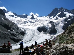
Glacier de la Pilatte from the Refuge
Refuge du Sélé: 2511m — Pointe des Boeufs Rouges: 3516m — Refuge de la Pilatte: 2577m — Altimeter log: ascent 1110m, descent 1045m.
Mont Gioberney – 19 July
At 3352m, Mont Gioberney is an easy objective from the Refuge de la Pilatte. The normal route is graded F: as an alternative we took the route via the NE ridge. This involves crossing the small snowfield below the ridge and joining the ridge at a notch below and to the SW of point 2934 (a prominent gendarme on the ridge). A moderate scramble and a short snow arète lead to a 30m rock step (graded III). The summit is a few minutes from the top of the step across easy ground (PD).
We came down by the normal route (the NE flank), which makes a wide loop down the Glacier du Gioberney to join the cairned track on rocky slopes leading NNE back to the refuge.
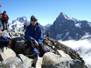
Summit of Mont Gioberney – Tony
Summit of Mont Gioberney – Murray
Refuge de la Pilatte: 2577m — Mont Gioberney: 3352m — Altimeter log: ascent 760m, descent 790m.
Col du Sélé – 20 July
We retraced much of our descent route from Pointe des Boeufs Rouges on the Glacier de la Pilatte, but heading left near the top to the Col du Sélé. The final 75m or so was rock. We reached the col shortly after sunrise, and after a short break started the long trek back down the Glacier du Sélé, past the Refuge du Sélé, and back to the car at Ailefroide.
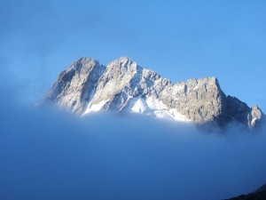
Les Bans above the Clouds
Refuge de la Pilatte: 2577m — Col du Sélé: 3283m — Ailefroide car park: 1514m — Altimeter log: ascent 745m, descent 1745m.
Refuge des Écrins – 21 July
From the road end above Ailefroide at Pré de Madame Carle we headed up the well-graded zigzags of the path leading to the Glacier Blanc and the refuge of the same name. Having set out a little after ten o’clock and arriving around mid-day we decided to have lunch and wait a couple of hours before going on to the Refuge des Écrins.
Not far beyond the Refuge du Glacier Blanc there is a choice: walk on the glacier or on the morraine rocks above. We opted for the rocks. The path finally joins the glacier around the 3000m contour, and an easy walk brings you to the foot of the path up to the Refuge des Écrins.
Pré de Mme Carle: 1874m — Refuge du Glacier Blanc: 2542m — Refuge des Écrins: 3175m — Altimeter log: ascent 1280m, descent 20m
Barre des Écrins – 22 July
We were away from the crowded refuge by 0340. Down onto the glacier, and keeping to our right (the glacier’s left) we headed up easy gradients to below the Col des Écrins. From here the route moves onto the slopes of the north face of the Barre and steepens considerably. It zigzags up the face (on frozen snow for our visit) under hanging séracs — not a place to linger, especially as there had obviously been a recent fall. Eventually we reached the top of the snow slope at its left side below the summit ridge, from where a level traverse leads to the Brèche Lory. The bergschrund (rimaye) has to be negotiated to reach the Brèche, which on this occasion involved a 10m ice climb.
The ridge is good rock, at this time virtually clear of snow and ice. To get onto the ridge itself we climbed diagonally up from a point a few metres to the left of the Brèche. The route then follows the ridge either on the crest or on the rocks just below on the left. The gradient is moderate to the subsidiary top of Pic Lory, drops briefly, then rises more steeply to the summit of the Barre itself. There are no particular technical difficulties, though there is inevitably some exposure (PD).
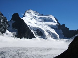
Barre des Écrins – North Face
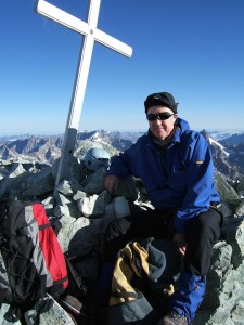
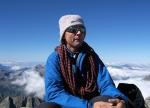
Summit of Barre des Écrins – Tony
Our descent was by the same route, with Murray saving time by lowering me off the Brèche Lory rather than setting up an abseil or waiting for me to climb down! The snow on the north face had softened by the time we were going back down, and we moved as quickly as my tired legs would allow until we were clear of sérac fall danger. We returned down the Glacier Blanc, past the Refuge des Écrins, and keeping to the glacier this time continued to the Refuge du Glacier Blanc, arriving in time for lunch and a celebratory beer.
With Murray having gone on ahead, I rested for a couple of hours at the refuge before taking my time back down the last 700m to the car at Pré de Mme Carle and the drive back to les Vigneaux.