Alpes-Maritimes – Statistics
Route details and statistics
The GR52a skirts the edge of the Mercantour National Park starting at Colmars (04 Alpes-de-Haute-Provence) in the valley of the Verdon, then heading east, south-east, and north-east to the Col de Tende (06 Alpes-Maritimes) in the corner of the French/Italian border. The FFRP Topoguide number 507 covers the GR5, GR52 and GR52a.
For our walk, total estimated time is calculated at 14 mins/km + 1.15mins/10m ascent, plus a rough allowance for any steep descent of about 15mins for 250m. It includes time for short stops. We were each carrying packs weighing about 10kg, and this timing worked quite well for us.
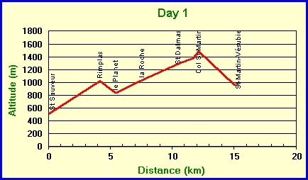
| St-Sauveur-s/-Tinée | alt (m) 500 |
ascent/ descent |
cum km | Total est time |
|
|---|---|---|---|---|---|
| Rimplas (SP 163) | 1020 | 520 | 4.2 | 2h00′ | GR5/52a |
| le Planet (SP 154) | 830 | -190 | 5.5 | 2h15′ | GR5/52a |
| la Roche (SP 139) | 1030 | 200 | 7.6 | 3h10′ | GR5/52a |
| St Dalmas | 1285 | 255 | 10.5 | 4h20′ | GR5 |
| Steep ascent | 1380 | 95 | 11.7 | 4h45′ | GR5 |
| Col St Martin (la Colmiane) | 1490 | 110 | 12.2 | 5h05′ | GR52a |
| St-Martin bridge | 950 | -540 | 15.1 | 6h00′ * | path * -250m / 15′ |
| St-Martin-Vésubie | 960 | 10 | 15.4 | 6h10′ | path |
| +1190 / -730 | |||||
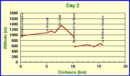
| St-Martin-Vésubie | alt (m) 960 |
ascent/ descent |
cum km | Total est time |
|
|---|---|---|---|---|---|
| le Bioulet (pt 1086 SP 285) | 1086 | 126 | 5.2 | 1h25′ | GR52a |
| far point | 1150 | 64 | 5.9 | 1h45′ | path |
| le Bioulet #2 | 1086 | -64 | 6.6 | 1h55′ | path |
| Pt 1296 | 1296 | 210 | 7.6 | 2h30′ | GR52a |
| High point 1360 | 1360 | 64 | 7.9 | 2h45′ | GR52a |
| Berthemont-les-Bains | 936 | -424 | 10.3 | 3h35′ * | GR52a * -300m / 15′ |
| lift to – | |||||
| D73 Bélvédère turn | 560 | ||||
| Camp de Milla | 645 | 85 | 12.9 | 4h20′ | road |
| Stream | 565 | -80 | 14.2 | 4h40′ | road / GR52a |
| la Bollène-Vésubie (village) | 690 | 125 | 15.3 | 5h10′ | GR52a |
| la Bollène-Vésubie (hotel) | 630 | -60 | 15.8 | 5h15′ | GR52a |
| +674 / -628 | |||||
See below for details about our route-finding problems at le Bioulet.
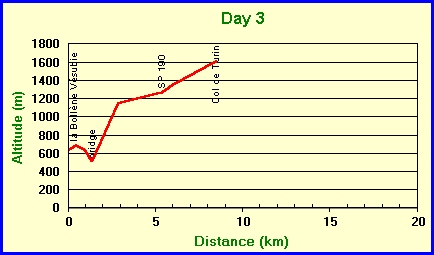
| la Bollène-Vésubie (hotel) | alt (m) 630 |
ascent/ descent |
cum km | Total est time |
|
|---|---|---|---|---|---|
| la Bollène-Vésubie (village) | 690 | 60 | 0.5 | GR52a | |
| la Bollène-Vésubie (hotel) | 630 | -60 | 1.0 | GR52a | |
| Bridge | 510 | -120 | 1.4 | 0h05′ | GR52a |
| gradient eases (after SP186) | 1150 | 640 | 2.9 | 1h40′ | GR52a |
| SP 190 | 1270 | 120 | 5.4 | 2h30′ | GR52a |
| rejoin forest road | 1340 | 70 | 6.0 | 2h45′ | GR52a |
| Col de Turini | 1604 | 264 | 8.5 | 3h50′ | GR52a |
| +1154 / -180 | |||||
| Col de Turini | alt (m) 1604 |
ascent/ descent |
cum km | Total est time |
|
|---|---|---|---|---|---|
| High point | 1735 | 131 | 1.3 | 0h35′ | GR52a |
| SP 182 | 1700 | -35 | 1.8 | 0h40′ | GR52a |
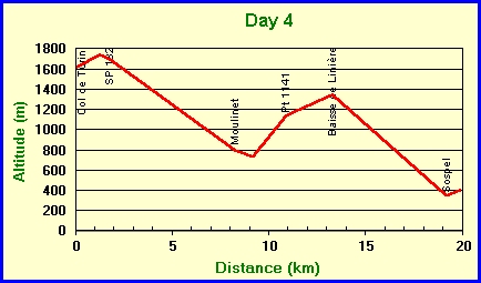
| Moulinet | 800 | -900 | 8.3 | 2h10′ | GR52a |
| bridge | 730 | -70 | 9.2 | 2h25′ | path |
| Pt 1141 | 1141 | 411 | 10.9 | 3h35′ | path |
| Baisse de Linière (SP22) | 1342 | 201 | 13.3 | 4h35′ | GR52 |
| Sospel (village) | 345 | -997 | 19.2 | 5h55′ | GR52 |
| Sospel (hotel) | 400 | 55 | 19.9 | 6h10′ | GR52 |
| +798 / -2002 | |||||
| Sospel (hotel) | alt (m) 400 |
ascent/ descent |
cum km | Total est time |
|
|---|---|---|---|---|---|
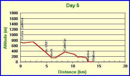
| taxi to – Col de Castillon | 728 | ||||
| 700 | -28 | 0.6 | 0h08′ | path | |
| 740 | 40 | 2.5 | 0h40′ | path | |
| leave road | 710 | -30 | 2.7 | 0h42′ | path |
| Jn GR51 | 336 | -374 | 5.0 | 1h15′ | path |
| Monti | 160 | -176 | 6.0 | 1h30′ | GR51 |
| Bridge below Monti | 145 | -15 | 6.7 | 1h40′ | GR51 |
| Castellar main square | 370 | 225 | 8.5 | 2h30′ | GR51 |
| 280 | -90 | 10.4 | 2h55′ | path | |
| 170 | -110 | 11.1 | 3h05′ | path | |
| 190 | 20 | 11.4 | 3h10′ | road | |
| 150 | -40 | 12.7 | 3h20′ | road | |
| Menton | 0 | -150 | 13.0 | 3h25′ | road |
| Menton Station | 0 | 0 | 14.0 | 3h40′ | road |
| +285 / -1013 | |||||
Route-finding at le Bioulet (day 2)
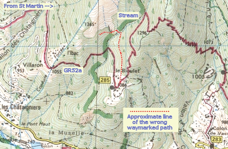
The line of the GR52a shown on the IGN TOP25 map is accurate, but not all the buildings at le Bioulet are shown. As you approach le Bioulet, pass between two concrete pillars either side of the road. About 200m further, go up the private drive with “no entry” sign. There was no signpost nor a GR waymark at this point in April 2005. Continue in the same direction to reach a notice board / signpost (probably no. 285, but we didn’t confirm this). Here you should pick up the waymarks again. The GR52a heads purposefully uphill in a north-easterly then northerly direction, and as shown on the map turns sharply south when it reaches the stream.
Do NOT take a lower WAYMARKED path which follows a more level route parallel to the road, heading north. The waymarks were bright and new in April 2005. This path does not turn back at the stream, but crosses it and continues to follow the direction of the road back towards St Martin, but higher up the hillside. It possibly connects with the dotted track shown ending at the large conduit.
We made the mistake of not passing the “no entry” sign and searched around in the woods for the path, eventually picking up the fresh waymarks of what turned out to be the lower path. We followed this over the stream and on for another few hundred metres before abandoning it and returning to le Bioulet, where we intersected with the correct path. We did not go as far as the notice board / signpost but could see it below us at the point where we found the right way.
The fresh white-and-red waymarks on the wrong path were confusing. We suspect that an alternative line for the GR52a is being or has been developed, possibly using the dotted track ending at the conduit. At the time of writing (May 2005) there is no mention of this on the FFRP website’s mise à jour section.