South West Coast Path – Day 28
Penberth Cove to Lamorna
26 September 2024
Distance on Coast Path: 6.8km; ascent: 241m
Total distance: 9.4km; ascent: 263m
Walking time: 2h 32′
Total time: 4h 19′
Overnight: Self-catering, Trewellard
I confess I was a little uneasy about today’s short walk. As I mentioned in my notes on Day 25 Lamorna to Penzance I’d heard mixed tales of how difficult and dangerous the section of Coast Path between Land’s End and Penzance was. Yesterday’s walk from Land’s End to Penberth Cove was anything but tricky, the most demanding section being the steep rocky steps from the Minack Theatre to Porthcurno, but even this is a tourist path with handrail protection on the steepest parts. However, given the mishap I’d suffered on that earlier day near Lamorna I was prepared to treat this section with care.
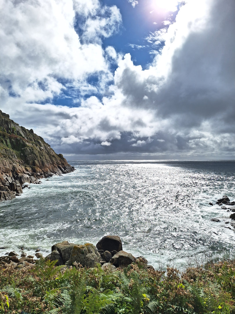
Sunlight on the sea at Pothguarnon
I followed the same pattern as yesterday, parking the car on the Lamorna lane close to the Lamorna Turn bus stop and taking the Coaster bus to the turn for Penberth Cove*. It had been stormy overnight and it was drizzling as I walked down to the coast. Rain was forecast for later so I had my waterproofs on. Inevitably the sun came out as soon as I reached the cove.
There was nothing remarkable about the Path for the first few kilometres. The only places where I could think anyone might find it difficult were short stretches where the path was narrow and exposed with a steep slope down to the sea unbroken by any trees or bushes. I made sure to tread carefully but didn’t feel particularly at risk.
I did get warned twice by people coming in the opposite direction – first by two women walking a dog, then by a man with a rucksack on his own. “There’s a really boggy bit ahead,” said one of the dog-walkers. “We had to turn back because the mud was too deep.” I filed this information under ‘probably exaggerated’ and carried on.
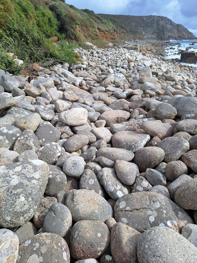
Boulder path at St Loy
There was one unusual stretch as the Path dropped down to shore level at the cove below the tiny hamlet of St Loy. It continued for a couple of hundred metres along the beach – not sand, not shingle, but large rounded boulders. A couple coming towards me were picking their way tentatively across as I set off. The boulders were dry, not slippery, and mostly firmly in place as I skipped from one to the next, getting to the far end without mishap. I stopped for a lunch snack and watched a man on his own come towards me across the boulders. We spoke briefly when he reached me: like me he was wearing waterproofs, and we agreed we were overdressed for the conditions but that it was more bother than it was worth to change. He went off ahead.
Setting off again I soon came to a place where a small stream crossing the path had spread to form a squelchy section maybe 20 metres across. “Yeah, exaggerated,” I thought.
But then I came to the real boggy bit.
The first thing was a yellow sign propped up at the side of the Path warning of “Improvement Works”. Round the next corner and there it was – a sea of brown mud glistening wetly in the pale sun and disappearing round the next slight bend. No stones or timbers to step on, no accessible firmer ground on either side, no option but to go through. So I did. The mud clutched at my boots, coming up to the top but not quite overtopping them. I slipped occasionally but didn’t fall, and despite one foot getting so stuck I began to get worried about getting it out I managed to extract it and continue. Round the bend a small mechanical excavator was parked a bit further along, marking the start of firmer ground. There was no sign of anyone working on the ‘improvements’.
After that it was back to normal. I came across a package lying on the path which turned out to be a set of flexible tent poles; they looked almost new. I left them in a prominent position at eye level, feeling sorry for whoever had dropped them.
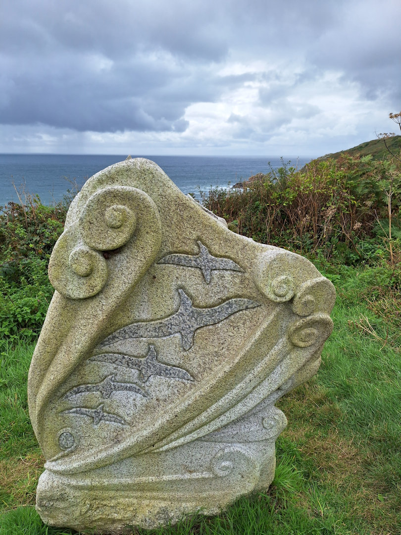
Memorial to the lives lost in the Union Star shipwreck 1981.
Shortly before the lighthouse at Tater-du there is a memorial just off the path. It commemorates the tragedy when the Union Star went aground off this point in December 1981. The Penlee lifeboat went to the rescue, and all hands from both vessels, 16 in all, lost their lives. The RNLI website has an account of the disaster.
RNLI: rnli.org/about-us/our-history/timeline/1981-penlee-lifeboat-disaster
From the lighthouse onwards the way became more rocky with the last couple of kilometres being mostly a matter of clambering over, round or between granite boulders as the path works its way down to the cove at Lamorna.
The man I’d met briefly at the end of the boulders at St Loy was sitting at one of the outside tables at the café. I bought a cup of tea and a piece of cake and joined him. He’d already taken off his waterproofs, and now I did the same. He was heading to Penzance; I admired but didn’t envy his plan.
Of course now I’d taken off my waterproofs, by the time I was driving back to my self-catering in Trewellard it was raining heavily. Sorry, trail buddy on your way to Penzance, you should have kept them on!
* I had planned to park in the small car park at the end of the narrow lane leading steeply down to Lamorna Cove. I knew this was a paying car park but what I hadn’t realised was that the charge for a full day was £10 and the machines both had hand-written signs saying they were cash only. Like almost everyone in these cashless days, I didn’t have £10 in cash.
Comments
South West Coast Path – Day 28 — No Comments
HTML tags allowed in your comment: <a href="" title=""> <abbr title=""> <acronym title=""> <b> <blockquote cite=""> <cite> <code> <del datetime=""> <em> <i> <q cite=""> <s> <strike> <strong>