
South West Coast Path – Day 40
Portwrinkle – Plymouth
1 October 2025
Distance on Coast Path: 21.0km; ascent: 297m
Total distance: 22.0km; ascent: 351m
Walking time: 5h 15′
Total time: 6h 59′
Overnight: Copthorne Hotel, Plymouth
I woke in the night around 3.00 and took more paracetamol, then slept until my alarm at 7.15. Sitting tentatively upright on the edge of the bed I took stock; I decided I felt quite a bit better than yesterday though still not 100% well. But I should be able to walk to Plymouth – my last day in Cornwall and the last of this visit.
My B&B hosts Ian and Lorraine had been out when I arrived. In messages we’d exchanged they said I should let myself in, so the first time we met was in the morning. They were very tolerant about me calling out ‘Hello!’ at the bottom of the stairs when there was no sign of breakfast at five past eight – apparently somewhere in the booking details it said that breakfast was at half past.
Ian offered to drive me back to Portwrinkle to pick up the Coast Path. When I was ready to leave I was surprised to find him waiting outside behind the wheel of a rather ancient black taxi. I sat in the back as he drove up the hill to the Finnygook Inn then down another narrow lane towards the coast. We passed the two German women heading the same way. Ian pulled up at the side of the lane with no houses in sight. “Here you are”, he announced, “the footpath’s just here.” I saw a wooden coast path sign leaning at an angle and pointing through the hedge into a field. I thanked him, grabbed my rucksack, and pushed through the hedge into the field behind as he drove away. I’d skipped past Portwrinkle without seeing any of it.
Once up on the low cliffs it was easy going past Whitsand Bay golf club, and I soon arrived at the secure gate at the entrance to the Tregantle Firing Ranges. I wasn’t surprised when the two Germans caught me up there – this time we introduced ourselves: they were Lucy and Edith, Lucy being the one with the better English. None of us had checked beforehand, but no red flags were flying (there was one tied to the gate) and the gate wasn’t padlocked so we were confident we could take the path through the ranges.
I’d seen Tregantle Fort on the map but hadn’t expected such a solid and imposing structure, nor that it was still in use. It was built between 1859 and 1865; according to Wikipedia it “is one of several forts surrounding Plymouth that were built as a result of a decision in Lord Palmerston’s premiership to deter the French from attacking naval bases on the Channel coast” (see here for more). The three of us took photos but I lingered longer and Lucy and Edith left several minutes before me.
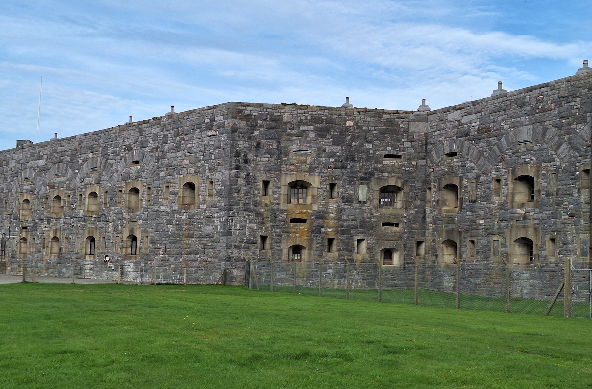
Tregantle Fort
Beyond the fort at the edge of the ranges a security gate opens onto a public road. But inside the gate a tempting well-kept gravel path runs parallel to the road, and I followed it downhill. Before long it twisted away from the road then straightened out again, but I sensed something wasn’t quite right. A quick check on my tracker confirmed that if I carried on I’d end up on the beach with no way of continuing, so I turned round looking for a narrow path I’d passed not long before which seemed to head back towards the road – this was confirmed by a dog-walker who was coming down the path as I reached it.
The Path now followed the public road for more than four kilometres, sometimes on the road itself, sometimes alongside. I hoped I might find a coffee stop in Freathy – no luck – or maybe the Whitsand Bay Holiday Park – no luck again, very ‘Private – Keep Out’.
On the sloping cliffs below the road odd single-storey houses were dotted randomly, some seemingly well-built, some no more than shacks. Beyond the holiday park the Coast Path dived off the road into this strange area. The houses were all different, each in its own plot, irregularly spaced and angled though mostly facing in the general direction of the sea. No-one was about: the whole area was deserted, though obviously inhabited. Were they all second homes and holiday lets or were some permanent homes? I couldn’t tell. Until the narrow path widened into a driveable track as it neared the road again, most didn’t seem to have access for vehicles. It was very strange.
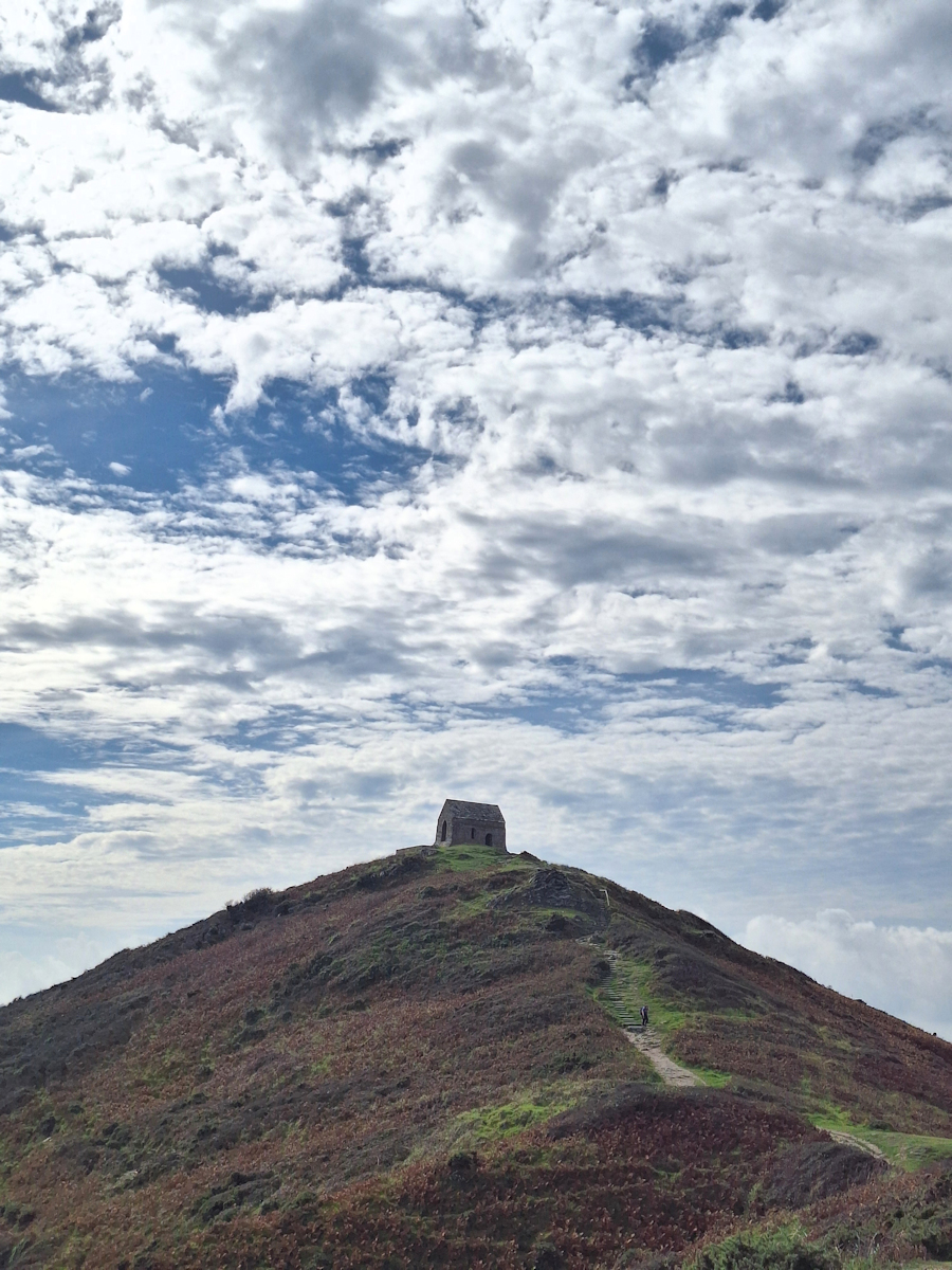
Rame Head and St Michael’s chapel (14th C)
The Path met the road at a junction and immediately left it again to follow the coast and the cliffs – still easy going – out to Rame Head, a significant landmark on the Channel coast. Just inland from the path is a car park and a Coast Watch station: although the official Coast Path cuts across the neck of the headland I opted to climb the short distance to the medieval chapel which stands on the cone-shaped point, silhouetted against silver clouds in a mid-day blue sky.
On the way back from the chapel I saw Lucy and Edith leaving on the path. I had wondered why I hadn’t seen them ahead of me on the road earlier, and had an idea what might have happened. They were too far away to greet, and anyway it was now half past twelve and I felt like a rest and something to eat. I would really have liked a coffee too – there had been no opportunity to get one since breakfast.
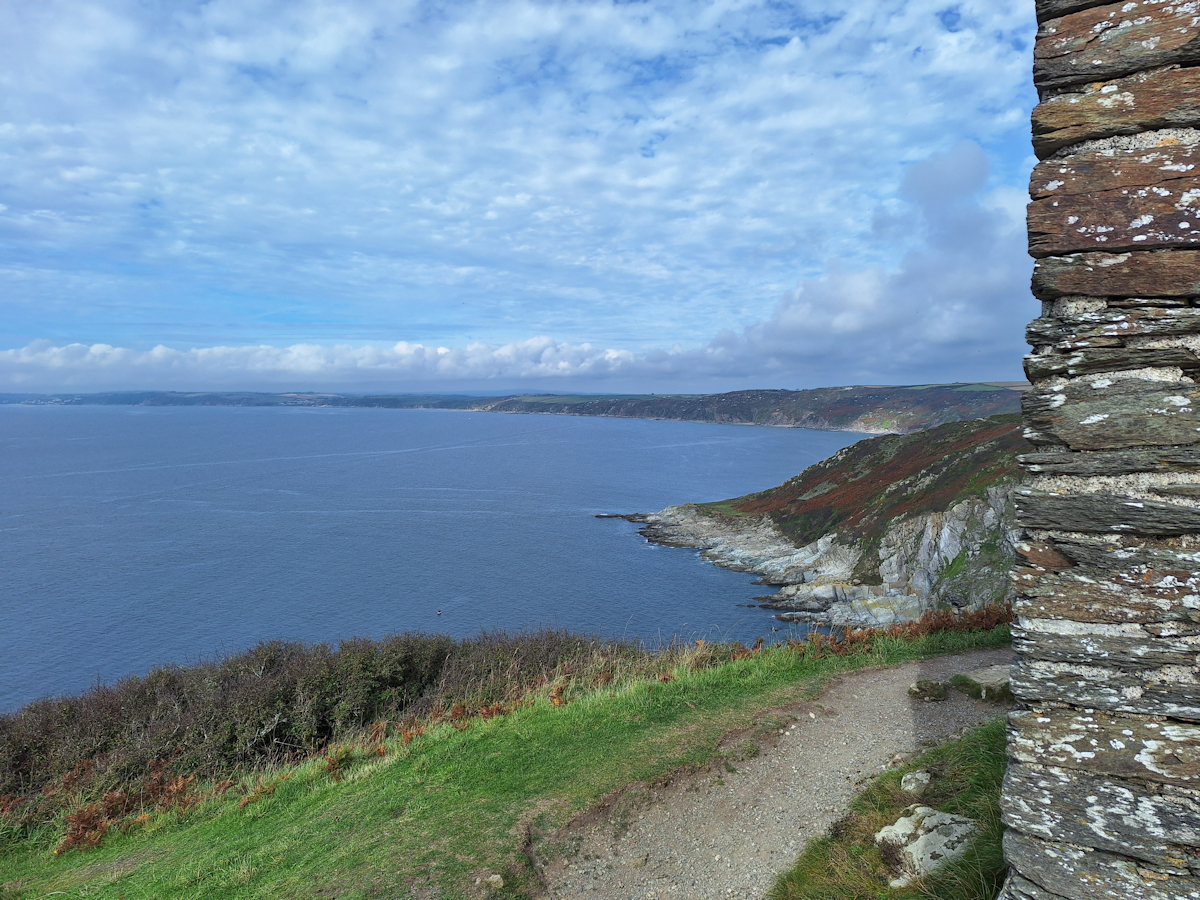
View back along the coast from Rame Head
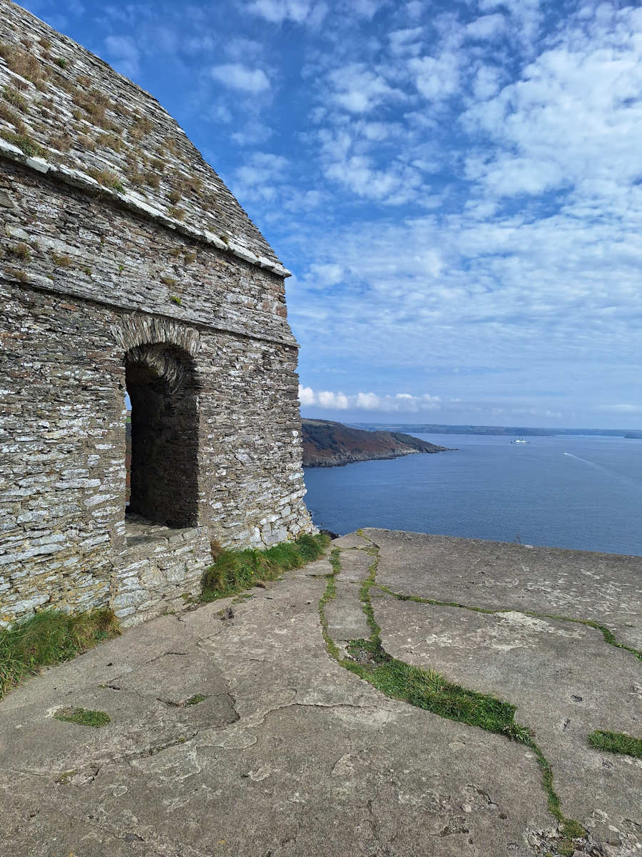
St Michael’s Chapel and view towards Plymouth Sound.
It was just after 1 o’clock when I set off again. It’s an easy path, wide enough for groups to walk together, heading first east then north before it reaches the village of Cawsand. But it’s also rather featureless and quickly becomes a dull four-kilometre schlep. A Royal Navy ship silently edged into view from Plymouth Sound; it barely seemed to be moving as it manoeuvred apparently purposelessly in the open water. I couldn’t get the idea out of my head that somewhere on that ship there was someone scanning me with sensors sharp enough to read the logo on my sunglasses.
There are two things to note about Cawsand. Getting there signals that you’ve almost reached Plymouth – it’s on Plymouth Sound rather than the open sea; there’s even a ferry to Plymouth. But even better, it’s the first place with a café since leaving Portwrinkle. The Shop In The Square sold me an americano and a packet of crisps and I sat outside on their tiny terrace to enjoy them.
I wasn’t paying attention when I heard “Hello!”. It was Lucy, who’d just come up the short passage to the shore. She and Edith had taken their coffees down to the harbour; she’d come back for a refill. If I’d like to join them I’d find Edith down there. So we sat chatting in the sun drinking our coffees and sharing crisps, and I confirmed my guess that they too had followed that path from the fort but hadn’t realised the mistake until they got to the beach, where anyway they’d taken a bit of a break – which is how they came to be behind me at Rame Head despite leaving the fort before me.
After a good break, and remembering there was a ferry to catch, we prepared to set off. They went in search of a toilet, I worked my way through the streets of Cawsand and its conjoined twin Kingsand soon to reach a gate marking the entrance to Mount Edgcumbe Country Park. A diversion sign which had been in place for at least two years (it was in the 2023 SWCP guide book) led uphill into mixed woodland. Waymarks disappeared but I kept on a broad track which contoured above a curious circular structure on the sea shore marked on the map as Fort Picklecombe. It looked more like a folly than a fort.
At the point where the diverted path should have turned downhill a newer diversion notice barred the way, a fallen tree apparently blocking the path. I carried on, getting less and less confident about finding the way as the path I was taking forked and other paths led off on either side. There were no waymarks, and I started cursing the Country Park for its lack of consideration. Getting more frustrated by the minute I ended up navigating by map and tracker through a maze of paths and tracks, though of course not every path was shown on the map. At one point I dropped down across an open field to join a driveable track and followed it on a twisting route past signs for the park’s National Camellia Collection. I was definitely not in the mood for that, nor the formal garden, nor the Orangery. I was glad at last to reach the exit gate and walk the last few hundred metres to the ferry quay.
“See you at the ferry”, Lucy, Edith and I had said to each other as we parted in Cawsand, and I was sorry not to see them there. I had a quarter of an hour’s wait for the next ferry at 4.30, but with the problems finding the way through Edgcumbe I realised they could be ahead of me or behind so I never got to say goodbye and wish them well for the rest of their journey. The ferry arrived and I stepped aboard, ending my walk in Cornwall.
Coda: Feeling tired, I got off the ferry, walked up a short bleak road and found a bus stop right by. A bus came along with “City Centre” on its destination sign. I got on. In the centre I walked through building works where Armada Way was being pedestrianised and found my hotel. In the early evening, feeling lightheaded, I went for a disappointing meal in a not-very-Greek Greek restaurant, walked back to the hotel and went to bed. Next morning the short walk to the station felt like a big effort. I slept much of the way on the train, getting home mid-afternoon. By six o’clock I felt really ill – so short of breath I could hardly manage the stairs. It was the start of a cough and cold that lasted more than two weeks. Having cut short two days ago I was lucky that I’d been able to walk the full Portwrinkle – Plymouth section without any trouble.
Comments
South West Coast Path – Day 40 — No Comments
HTML tags allowed in your comment: <a href="" title=""> <abbr title=""> <acronym title=""> <b> <blockquote cite=""> <cite> <code> <del datetime=""> <em> <i> <q cite=""> <s> <strike> <strong>