
South West Coast Path – Day 39
Polperro – Downderry
30 September 2025
Distance on Coast Path: 17.0km; ascent: 417m
Total distance: 18.3km; ascent: 417m
Walking time: 4h 37′
Total time: 6h 22′
Overnight: Sheviock Barton B&B
I woke up soon after 2am with a seriously sore throat. Not just a niggle; one of those “Uh-oh! What am I in for now?” sore throats. Only half awake, I stumbled around to find my paracetamol and water bottle, gulped down two tablets, and thankfully dropped back off to sleep before too long.
My throat was feeling just as bad when I woke with the alarm at 7.10. I was thrown for a moment when I looked out of the window and couldn’t see anything. “What is the matter?” I thought, before I realised it was thick fog outside. I took more paracetamol before going down for breakfast.
With a coffee in front of me I assessed the situation. I didn’t feel great, but on the other hand I didn’t feel so ill that I couldn’t walk. There were several places along the route where I could pick up a bus; none of the bus routes ran the whole way along the coast, but it did give me some options. The first place of any size would be Looe; I reckoned I could make it that far, and depending on time and how I felt I could decide my next options there. And so I left the Crumplehorn Inn at 9.10 and Polperro at 9.30.
With my level of awareness down to about 75% I didn’t take in much of the Coast path from Polperro to Looe, but then the SWCP guidebook doesn’t have much to say about it either. Porthallow and Talland Bay came and went and by 11.00 I had reached the road at Hannafore which leads into the centre of Looe.
There is one thing I do remember however: I had paused at a path junction where a ‘Public Footpath’ sign pointed straight ahead on a clear grass path across a field, and a ‘Coast Path’ sign forked off to the right down to the bottom of the field. Keen to make as little effort as possible I was looking at the map to see if straight ahead was an easier option when two women, fit-looking with walking poles and day rucksacks caught me up. Greetings exchanged, the choice of path discussed, then general chat revealed they were from Germany and were walking the whole of the Coast Path from Minehead to Poole in one visit with accommodation and luggage transport arranged by one of the companies that does that sort of thing. One of them did all the talking, the other obviously spoke little English but smiled and nodded along as her companion translated. I did find out they were staying that night in the Finnygook Inn in Crafthole where I was booked for an evening meal. They chose the official route downhill while I carried straight on. They passed me again before Looe, going at a strong pace as I plodded uphill.
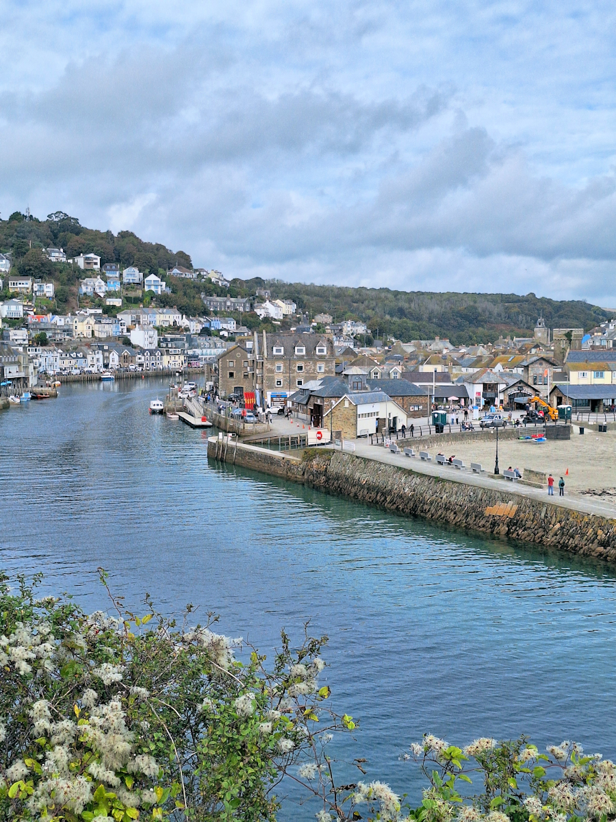
Approaching Looe along Looe River
The Looe River separates West Looe and East Looe, and although not generally known as ‘the Cornish Budapest’, the two sides have slightly different vibes and differentiate themselves enough to have separate coats of arms. Pragmatically, the arms for the complete town combine the two ‘per pale’ (split vertically).
Dragging my feet and in need of a coffee break I walked along the river through West Looe, crossed the bridge (nothing like Budapest’s), turned back down the river through East Looe, bought a coffee and a pastry in Pier One and sat outside to look at the map and consider what to do next. It was about 11.30.
The next two coastal villages were Millendreath and Seaton. The latter was about six and a half kilometres away, but crucially was on the route of the 75 bus which I needed to get to my B&B at the end of the day. Although I didn’t feel great I decided I could walk that far and think again when I got there.

Teabag Bentley
It was 12.15 when I left Looe, soon passing through an area of expensive properties above Plaidy beach. One of them was the home of The Cornish Coffee Company (they sell tea as well).
After a 1 o’clock lunch break at Millendreath I reached Seaton at around 2.15. It’s a nondescript place with an odd row of new detached houses, each different, but looking like they were built of Lego.
I sat on a wall by the beach – sitting seemed a worthwhile thing to be doing. Downderry was only just over two kilometres away first along the sea wall and then the beach (tide permitting). I checked the tide times – the tide was falling. Another two kilometres? OK.
By the time I reached Downderry I’d had enough. My planned destination – Portwrinkle – was only another five kilometres but it was five kilometres too far. I took a footpath from the beach to the coast road, found the bus stop (it had a bench!) and settled down to a long wait for the bus.
I hadn’t been able to find an affordable overnight stay in Portwrinkle (another place I’d never heard of) and to reach my B&B in Sheviock on foot from there would take about an hour. My original plan had been to get the bus to the B&B, walk the kilometre back uphill to the Finnygook Inn at Crafthole for a meal – I’d booked for 7.00 – and walk back down the hill. This now didn’t seem like such a good idea. Instead, I got off the bus at the Finnygook about 5.30 and ordered my meal soon after 6.00. I had seabass, and it was very good!
The two German women I’d met earlier came in for their meal while I was eating; we waved to each other. When I was ready to leave I went over to their table, keeping a safe distance in case I was infectious, and we chatted for a few minutes, parting with “probably see you tomorrow”. It was dusk as I set off down the narrow lane, and within a few minutes it was dark enough to get my torch out. Luckily there wasn’t any traffic. Arriving in the small village without much idea of where to find my overnight stay I was lucky to catch the sign in my torchlight after only a few minutes. It was now 7.45 in the evening; I took paracetamol and went straight to bed.
Updated 7 May 2026
Downderry – Portwrinkle (reversed)
22 April 2026
Distance on Coast Path: 5.1km; ascent: 179m
Total distance: 7.9km; ascent: 179m
Walking time: 1h 47′
Total time: 2h 22′
On a three-day visit to Plymouth I planned to fill in the gap I left last year between Downderry and Portwrinkle when I wasn’t feeling very well (see above). I took the bus from Plymouth city centre which goes on the ferry between Devonport and Torpoint. This should have connected with a second bus to take me to Downderry to continue the walk to Portwrinkle but delays on the ferry service meant I missed the connection. I quickly devised Plan B, which was to stay on the bus I was already on and take it to the nearest point on the stretch of the Coast Path I was aiming for. That point turned out to be a road junction close to Tregantle Fort. From there I could walk west to Portwrinkle – a distance of about 3km – and then continue to Downderry to wait for the bus back to Torpoint. I would walk the missing section in the reverse direction.
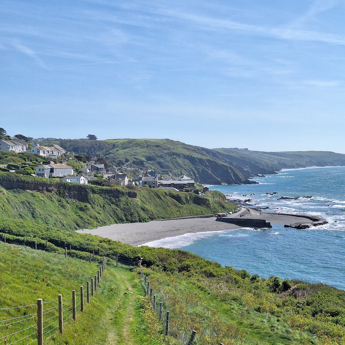
Portwrinkle
There’s not much to say about this short section other than to recognise I made a wise decision not to attempt it when I was feeling poorly. It has many more ups and downs than the earlier part of that day: I think I would have given up on what would have been the long slow grind up from Downderry. Otherwise it was Coast Path as usual, with the bonus of fine weather, blue sky, dry paths and tracks and the easterly wind – still strong after the gales of the previous days – blowing me along as I headed west.
Plan accomplished, I settled down to wait at the same bus stop in Downderry where I had waited last time, and like last time the bus appeared only 15 minutes late to take me back to Torpoint and the Plymouth ferry.
Comments
South West Coast Path – Day 39 — No Comments
HTML tags allowed in your comment: <a href="" title=""> <abbr title=""> <acronym title=""> <b> <blockquote cite=""> <cite> <code> <del datetime=""> <em> <i> <q cite=""> <s> <strike> <strong>